Squall Line Moving Into Western Michigan Friday Night Bringing Isolated Tornado and 60 MPH Wind Threat Across Grand Rapids and Chicago Areas After 10 PM
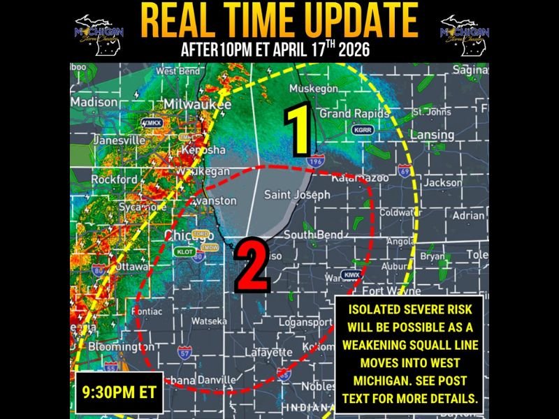
MICHIGAN AND ILLINOIS — A mature squall line was tracking onto Lake Michigan and stretching southwest back into Illinois at 9:30 PM Eastern Friday, April 17, 2026, with forecasters issuing a real-time update warning of an isolated severe weather risk as the line moves into western Michigan after 10 PM. While the line is expected to weaken with the loss of daytime heating, two distinct risk zones have been identified with varying levels of tornado and damaging wind potential for communities across the region.
Radar imagery showed the intense squall line pushing eastward from the Chicago and Milwaukee corridor toward western Michigan, with the southwest counties of Michigan carrying the highest instability and therefore the greatest severe weather risk as storms arrive in the next 60 to 90 minutes from the time of the update.
Zone 2 Carries the Higher Tornado Risk
The Zone 2 area covering the southwest counties of Michigan including the Saint Joseph, South Bend, and surrounding corridor carries the more significant severe weather threat Friday night. Forecasters noted that more storm fuel is currently present in this zone, meaning scattered damaging winds and a tornado or two are possible as storms first arrive in the area within 60 to 90 minutes of the 9:30 PM update.
This zone benefits from lingering instability that has not yet been exhausted by the evening hours, giving incoming storms just enough fuel to maintain severe capability as they push onshore from Lake Michigan into southwest Michigan communities.
Zone 1 Sees Lower But Real Risk
The Zone 1 area covering Grand Rapids, Muskegon, Kalamazoo, and surrounding west-central Michigan communities carries a lower but still real severe weather risk Friday night. Damaging winds up to 60 mph are possible in this zone, with an isolated tornado also possible if instability lingers later than currently expected.
Further north and east across Michigan including Lansing, Jackson, and St. Johns, minimal instability may support an isolated severe storm through midnight before storm fuel is quickly exhausted and conditions settle down for the remainder of the night.
What Residents Should Do Right Now
With storms expected to arrive across southwest Michigan within 60 to 90 minutes of the 9:30 PM update, residents in Zone 2 communities including Saint Joseph, South Bend, and surrounding areas needed to be sheltered and weather-alert immediately. Weather radios should remain on throughout the evening across both zones until forecasters confirm the threat has completely passed.
Further east outside the marked risk zones, rain and storms will move in later overnight but with little to no severe weather support expected given the depleted storm fuel available after midnight.
Were you tracking Friday night’s squall line across Michigan or Illinois? Share your experience and stay connected at SaludaStandard-Sentinel.com.