Snow Squall Line Sweeps Into Northwestern Lower Michigan Bringing Whiteouts, 35 MPH Wind Gusts and Quick Bursts of Snow Tonight
MICHIGAN — A fast-moving snow squall line is pushing into northwestern Lower Michigan Friday evening, bringing sudden bursts of heavy snow, strong wind gusts, and rapidly deteriorating travel conditions across the region.
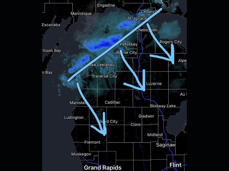
Radar imagery shows the squall line advancing from the Lake Michigan shoreline inland through areas including Traverse City, Petoskey, and Cheboygan, with the system expected to continue southeast overnight.
Snow Squall Line Moving Quickly Across Region
The incoming band of snow is organized and moving steadily, with a clear trajectory from northwest to southeast. Communities along the Lake Michigan coast were among the first to see impacts, with the line now pushing inland toward central portions of northern Lower Michigan.
Forecasters indicate that this system will continue tracking southeast through the night, eventually impacting areas farther inland before exiting by early Saturday morning. Because of its speed, conditions can change dramatically within a short period of time as the squall passes through.
Visibility Could Drop Below Half a Mile
One of the biggest concerns with this event is the potential for sudden and severe reductions in visibility. Snow squalls are capable of creating near-whiteout conditions, with visibility dropping below half a mile at times.
Drivers may encounter rapidly changing road conditions, where clear roads can quickly become snow-covered and slick within minutes. Blowing snow combined with falling snow further reduces visibility, especially in open areas. These sudden changes make travel particularly hazardous during the evening and overnight hours.
Wind Gusts Up to 35 MPH Increase Impact
In addition to heavy bursts of snow, wind gusts of 35 mph or higher are expected to accompany the squall line. These winds will enhance blowing snow, worsening visibility and creating drifting on roadways.
The combination of gusty winds and quick snowfall can make conditions feel more severe than total snowfall amounts might suggest. Even after the main band passes, lingering winds may continue to affect travel conditions.
Quick Snow Accumulation Possible in Short Time
While this is not expected to be a prolonged snow event, quick accumulation of up to a half inch of snow is possible within a short window as the squall moves through.
This rapid accumulation can create slick surfaces on untreated roads, bridges, and overpasses. The sudden nature of the snowfall increases the risk of accidents, especially for drivers unprepared for winter conditions late in the season.
Conditions Improve After Squall Moves Southeast
As the snow squall line continues its southeast progression, conditions are expected to improve behind it. Skies may begin to clear, and visibility will gradually return once the heavier snow exits a given area.
However, colder air following the system could keep roads icy in some locations into early Saturday morning. Residents are urged to remain cautious even after the snow ends, as lingering impacts may persist.
Have you encountered sudden snow squalls or rapidly changing road conditions in your area tonight? Share your experience and stay updated with the latest alerts at SaludaStandard-Sentinel.com.