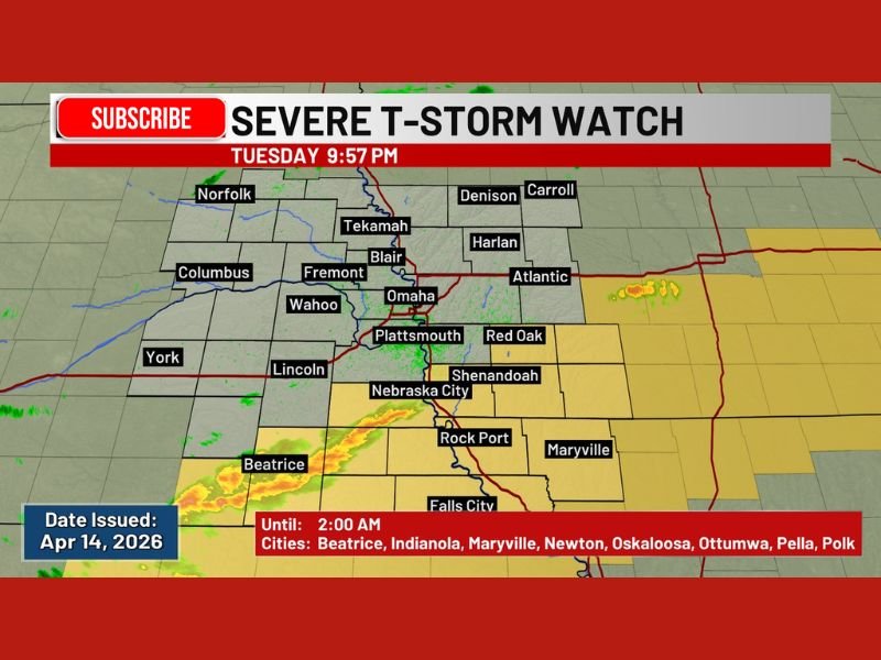
Severe Thunderstorm Watch Issued Across Nebraska and Iowa Tuesday Night With Dangerous Storms Threatening Omaha, Lincoln, and Surrounding Communities Until 2 AM
EASTERN NEBRASKA — A Severe Thunderstorm Watch is currently in effect for a large portion of eastern Nebraska and southwestern Iowa through 2:00 AM Wednesday, April 15, 2026, as atmospheric conditions remain favorable for the development of dangerous storm activity overnight.
The watch covers a wide swath of the region, placing millions of residents across multiple counties on alert for rapidly developing severe weather during the late-night hours.
What a Severe Thunderstorm Watch Means
A Severe Thunderstorm Watch does not mean severe storms are occurring at this moment — it means that atmospheric conditions are highly favorable for their development. Residents in the affected areas should remain weather-aware, keep a close eye on local updates, and have a plan ready in case warnings are issued.
Those in the watch zone should avoid being outdoors unnecessarily and ensure they have a reliable way to receive emergency alerts throughout the night.
Cities and Communities Under the Watch
The watch covers a broad area of eastern Nebraska and southwestern Iowa, with specifically named cities including Beatrice, Indianola, Maryville, Newton, Oskaloosa, Ottumwa, Pella, and Polk. Additional communities visible within the watch zone include Omaha, Lincoln, Fremont, Blair, Plattsmouth, Wahoo, Nebraska City, Rock Port, Shenandoah, Red Oak, Atlantic, Harlan, Tekamah, Norfolk, Denison, Carroll, Falls City, York, and Columbus.
The watch was issued on April 14, 2026, and remains valid until 2:00 AM local time.
What Residents Should Do Right Now
Anyone living within or near the watch zone should monitor local weather broadcasts closely and be ready to act quickly if a Severe Thunderstorm Warning is issued for their specific county. Severe thunderstorms can produce damaging winds, large hail, and dangerous lightning with little warning once they develop.
Residents are encouraged to charge devices, keep emergency supplies accessible, and bring in any outdoor items that could be displaced by strong winds. Do not wait for a warning to begin preparing — take action now while conditions allow.
Are you in the path of tonight’s severe thunderstorm threat across Nebraska or Iowa? Stay safe and share your updates with fellow readers at SaludaStandard-Sentinel.com.