Washington Winter Surprise Brings Record March 13 Snowfall to Seattle as Rare Storm Delivers Hours of Snow
WASHINGTON — A rare late-season winter event brought measurable snowfall to Seattle on Friday, creating an unusual weather moment for the Pacific Northwest and setting a new daily snowfall record for March 13. Preliminary observations from Seattle–Tacoma International Airport show about 3 inches of snow, making it the snowiest March 13 ever recorded in the city.
The snowfall arrived as a weak atmospheric river drifted north from Oregon into western Washington while colder air settled behind a recent windstorm. The combination of moisture and near-freezing temperatures allowed snow to fall across parts of the Seattle area for several hours.
Narrow Band of Cold Air Created Ideal Snow Setup
Meteorologists say the snowfall occurred because of a narrow atmospheric “sweet spot” that developed between Seattle and areas south toward Olympia. Cold air settled along the northern side of a frontal boundary while moist Pacific air continued to move inland.
This combination allowed precipitation to fall as snow in some areas despite temperatures hovering very close to freezing. The added cooling from steady precipitation helped lower temperatures just enough to support accumulating snow in localized areas. Communities within that narrow corridor experienced the best conditions for snowfall, especially locations with slightly higher elevation.
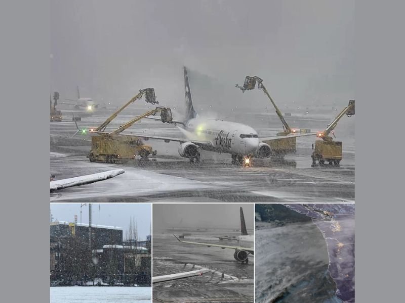
Sea-Tac Airport Recorded Several Hours of Snow
Seattle–Tacoma International Airport, which sits around 400 feet above sea level, was directly inside the zone where snow fell steadily for hours. Temperatures hovered around 32 degrees, allowing snow to accumulate gradually throughout the day.
While some areas north of Seattle remained slightly too warm for snow to stick, Sea-Tac and surrounding areas experienced extended snowfall that ultimately pushed totals to about 3 inches. Despite the snowfall, roads across much of the region avoided major impacts because warm conditions earlier in the week kept pavement temperatures relatively high.
Sharp Temperature Differences Across Western Washington
One of the most striking features of the storm was how quickly temperatures changed across relatively short distances.
While Seattle hovered near freezing with snow falling, nearby cities recorded significantly warmer readings. Observations showed temperatures around 35 degrees in Tacoma, 37 degrees in Chehalis, 45 degrees in Kelso, and 55 degrees in Vancouver, Washington. This dramatic temperature gradient highlighted how narrow the snow-producing zone was during the event.
Rare Snow Event for the Month of March
March snowfall in Seattle is relatively uncommon, which makes the event particularly notable for meteorologists tracking seasonal weather records. The 3-inch snowfall recorded at Sea-Tac surpasses the previous March 13 record of 1.7 inches set in 1955, marking the snowiest occurrence for that date in city records.
The snowfall has also shifted seasonal statistics in interesting ways. Seattle now has recorded more snow this winter than during the previous winter season, and the March snowfall ranks among the snowier March events historically observed in the city. Weather experts also note that this is only the third winter in which Seattle’s first measurable snowfall occurred in March, and just the sixth winter where March became the snowiest month of the season.
Snow Expected to Fade as Wetter Pattern Develops
Forecasters say the snow was expected to taper off by late evening as moisture decreased across the region. A few additional snow showers were possible overnight, especially in foothill areas of King and Snohomish counties, though accumulations were expected to remain light. Looking ahead, meteorologists believe the region may now shift toward a much wetter weather pattern.
Forecast models suggest a stronger atmospheric river could develop over the Pacific Northwest next week, bringing heavy rain to parts of Washington, Oregon, and possibly southern British Columbia. If that system develops as expected, forecasters say flooding concerns could become a possibility in some areas.
Residents across the Pacific Northwest are encouraged to continue monitoring forecasts as weather patterns shift from rare late-season snow toward potential heavy rainfall. Readers experiencing unusual weather in their communities can share photos and updates with others by visiting SaludaStandard-Sentinel.com.