Dangerous Thunderstorm Line Targets Birmingham and Tuscaloosa, Alabama as Severe Storm Warning Issued for Jefferson, Blount, Walker and Tuscaloosa Counties
BIRMINGHAM, ALABAMA — A powerful line of thunderstorms pushed across western and central Alabama Friday evening, prompting a Severe Thunderstorm Warning for parts of Walker, Tuscaloosa, Blount, and Jefferson counties as the storms advanced toward the Birmingham metro area.
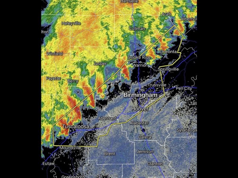
Weather radar showed a strong band of intense thunderstorms stretching from Fayette and Jasper south toward Tuscaloosa, with the storm line moving east toward communities including Warrior, Oneonta, Springville, and Trussville.
Forecasters warned the storms could produce damaging wind gusts, heavy rainfall, frequent lightning, and hail as the system continued moving across the region.
Strong Storm Line Approaching Birmingham Metro
Radar imagery revealed a well-organized line of storms pushing eastward toward Birmingham, with the most intense cells already moving across Tuscaloosa County and into northern Jefferson County.
Communities along the storm’s path include Smoke Rise, Warrior, Oneonta, and Springville, where heavy rain and strong winds were expected as the system continued tracking across the area.
The storm line appeared to be strengthening as it approached more populated parts of central Alabama, increasing concerns for possible wind damage and localized flooding.
Severe Thunderstorm Warning Covers Multiple Counties
The severe thunderstorm warning was issued for southeastern Walker County, Tuscaloosa County, Blount County, and Jefferson County, with the warning scheduled to remain in effect until 7 p.m. local time.
Meteorologists indicated the strongest storms within the warning area were capable of producing dangerous lightning, strong wind gusts capable of knocking down tree limbs, and bursts of intense rainfall.
Drivers traveling along major routes including Interstate 20/59 and Interstate 65 near Birmingham were advised to use caution due to reduced visibility and rapidly changing weather conditions.
Storms Continue Moving East Across Central Alabama
As the storms advanced eastward, additional communities including Hoover, Trussville, Alabaster, and Pell City could see heavy rain and gusty winds as the system moved through central Alabama.
The leading edge of the storm line showed signs of strong winds and heavy precipitation, which can create sudden weather hazards for residents and commuters.
Meteorologists urged residents across the warning area to remain indoors during the storms and to stay alert for possible updates if conditions worsen.
Residents Urged to Monitor Weather Alerts
Officials recommend residents keep weather alerts enabled on mobile devices and remain aware of local forecasts as severe storms continue moving across the region.
Thunderstorms capable of producing damaging winds can develop quickly, especially along strong storm lines like the one currently impacting central Alabama.
If you experience storm damage or capture photos of the severe weather in Alabama, share them with our newsroom at SaludaStandard-Sentinel.com as we continue covering severe weather events affecting communities across the United States.