Southern Ontario Faces Prolonged Winter Onslaught as Forecasts Signal 1–3 Feet of Snow Through Month’s End
ONTARIO — Residents across Southern Ontario are being warned to prepare for a prolonged and intense stretch of winter weather, as long-range snowfall models and meteorologist analysis point toward 1 to 3 feet of total snow accumulation from now through the end of the month.
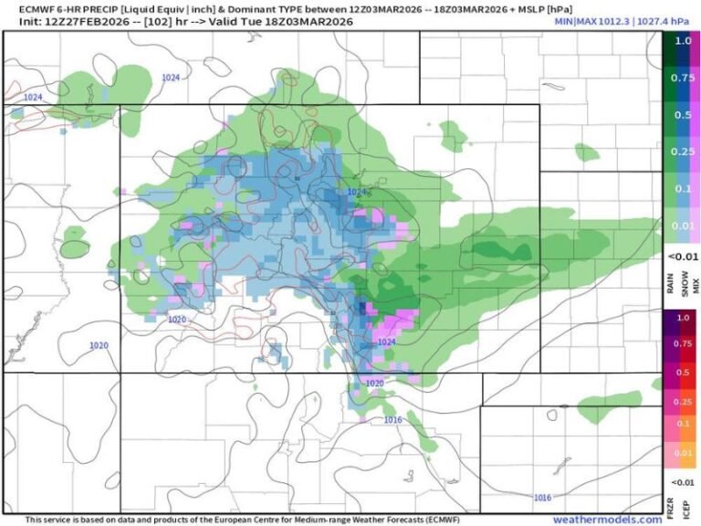
Forecast guidance indicates that the region is entering a highly active winter pattern, driven by repeated clipper systems and persistent lake-effect snow, rather than a single major storm. This setup favors frequent snowfall events, compounding totals over time and increasing long-term impacts on travel, infrastructure, and daily life.
Snowfall Totals Could Accumulate Rapidly Over Time
Model projections show widespread double-digit snowfall totals across Southern Ontario, with several areas repeatedly highlighted for 15 to 30 inches of snow, and localized corridors potentially exceeding three feet by late January.
Unlike classic snowstorms that deliver snow in one event, this pattern is expected to layer snowfall gradually, making road clearing and snow management more difficult as snow arrives in waves with little recovery time in between.
Clipper Systems to Keep Snow Falling Frequently
Fast-moving Alberta clipper systems are expected to pass through the Great Lakes region over the next couple of weeks. While individual clippers may only produce moderate snowfall, their frequency is the primary concern.
Each system will reinforce cold air, reset lake-effect conditions, and maintain nearly continuous snow chances, especially downwind of the Great Lakes.
Lake-Effect Snow Adds to the Threat
Lake-effect snow is expected to play a major role in boosting totals, particularly in regions vulnerable to persistent snow bands. These bands can produce heavy snowfall rates in narrow areas, rapidly increasing accumulations over short periods.
Communities affected by repeated lake-effect bursts may experience uneven snow distribution, with some locations receiving far more snow than nearby areas.
Travel and Infrastructure Impacts Likely to Increase
With snowfall spread across many days, travel disruptions are expected to become more common, especially on secondary roads and rural routes. Snow removal operations may struggle to keep up if snowfall intervals remain short.
Cold temperatures will also limit melting, allowing snow to accumulate and compact, raising the risk of icy surfaces and prolonged hazardous driving conditions.
What Residents Should Prepare For
- Multiple snow events rather than one storm
- Widespread 1–3 foot snowfall potential by month’s end
- Persistent lake-effect snow in vulnerable areas
- Ongoing travel difficulties and slow commutes
- Limited recovery time between systems
Meteorologists emphasize that while exact totals may vary by location, confidence is growing that Southern Ontario is entering one of its most active winter periods of the season.
As forecasts continue to evolve, residents should remain alert, plan ahead for extended winter conditions, and monitor local advisories closely.