60 MPH Wind Gusts and Quarter Size Hail Strike Central North Carolina Under Severe Thunderstorm Warning Targeting Greensboro, Burlington, Hillsborough, and Mebane
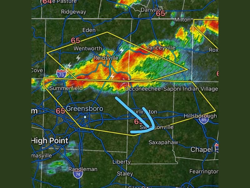
GREENSBORO, NC — A Severe Thunderstorm Warning was issued for northern Alamance County, northern Orange County, and northern Guilford County in central North Carolina until 10:15 PM EDT, as severe thunderstorms located along a line extending from near Reidsville to near Ellisboro moved southeast at 30 miles per hour bringing 60 mile per hour wind gusts and quarter sized hail toward a densely populated stretch of the Piedmont region.
Radar indicated storms were actively moving through the warned corridor at 9:29 PM EDT, with the warning polygon encompassing a wide swath of communities including Greensboro, Burlington, Graham, Hillsborough, Mebane, Elon, McLeansville, Summerfield, Gibsonville, and Stokesdale.
60 MPH Winds and Quarter Size Hail Pose Immediate Threat
The primary hazards associated with the severe thunderstorm line included wind gusts reaching 60 miles per hour and quarter sized hail measuring approximately one inch in diameter. Wind gusts of this magnitude were expected to cause roof damage, siding damage, and significant tree damage across the warned communities, while quarter sized hail posed a direct threat to vehicle surfaces and exposed property throughout the impact zone.
Radar imagery showed intense reflectivity returns concentrated across the Reidsville, Wentworth, and Summerfield corridor, with the storm line pushing southeast at 30 miles per hour directly toward the Greensboro and Burlington metro areas.
Major Highway Corridors Included in Warning Zone
The Severe Thunderstorm Warning specifically included major highway segments within the warned area, placing travelers on Interstate 85 between mile markers 127 and 131 and Interstate 40 between mile markers 132 and 161 and between mile markers 217 and 226 within the active hazard zone during the warning period.
Motorists traveling along these highway segments were at immediate risk from fallen trees, wind-blown debris, and reduced visibility associated with the severe thunderstorm line moving through the central North Carolina corridor at 9:29 PM EDT.
Greensboro and Surrounding Communities at Immediate Risk
The storm line’s southeast movement at 30 miles per hour placed Greensboro directly in the path of the warned severe thunderstorms as they pushed out of the Reidsville and Summerfield area. Burlington, Graham, Hillsborough, and Mebane all fell within the warning polygon as the squall line advanced toward the populated Piedmont communities of central North Carolina through the warning valid period ending at 10:15 PM EDT.
Residents across all warned communities were urged to move indoors immediately, stay away from windows, and secure any loose outdoor property ahead of the arriving 60 mile per hour wind gusts and hail-producing storm line.
For continuing coverage of severe weather events and critical storm analysis across the United States, visit SaludaStandard-Sentinel.com.