Tornado Watch and Damaging Wind Gusts up to 80 MPH With 1.75 Inch Hail Threatening St. Louis Counties as Organized Storm Cluster Arrives Around 10 PM
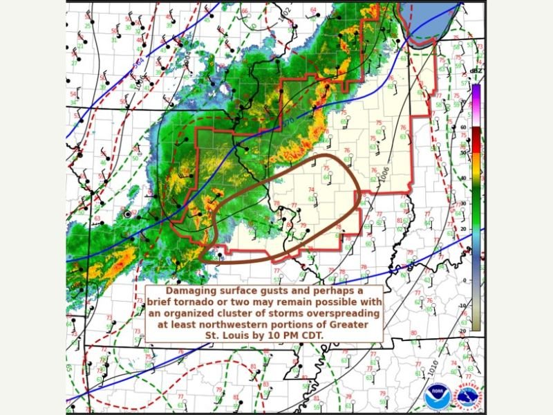
ST. LOUIS, MISSOURI — The Storm Prediction Center issued Mesoscale Discussion 486 valid until 10:45 PM CDT Friday, April 17, 2026, concerning Tornado Watch 131 as an organized cluster of storms was bearing down on St. Louis area counties with an expected arrival around 10 PM CDT. The discussion warned of damaging surface wind gusts reaching 65 to 80 mph, hail up to 1.00 to 1.75 inches in diameter, and the possibility of brief spin-up tornadoes as the storm complex overspreads at least the northwestern portions of Greater St. Louis.
Forecasters specifically called out northwestern St. Louis counties as the area most likely to feel the brunt of the organized storm cluster, with damaging gusts and a brief tornado or two remaining possible as the system pushes into the metro area during the late evening hours.
SPC Mesoscale Discussion Highlights Key Threats
The Storm Prediction Center’s Mesoscale Discussion painted a clear and concerning picture of what St. Louis area residents could expect as the storm cluster arrived. Most probable peak wind intensity was forecast at 65 to 80 mph — strong enough to cause widespread structural damage, snap large trees, and generate significant power outages across affected neighborhoods throughout the St. Louis metro region.
Hail reaching 1.00 to 1.75 inches in diameter accompanied the storm system, placing vehicles, rooftops, and anyone caught outdoors at serious risk of damage and injury as the cluster pushed eastward into Missouri Friday night.
Spin-Up Tornadoes Cannot Be Ruled Out
Beyond the damaging wind and hail threats, forecasters noted that brief spin-up tornadoes remain possible as the organized storm cluster overspreads northwestern portions of Greater St. Louis. Spin-up tornadoes embedded within organized storm clusters are particularly hazardous because they develop with minimal warning, last only briefly, but can cause intense and localized damage along their short paths through densely populated neighborhoods.
Residents across all St. Louis area counties were urged to treat any tornado warning issued for their specific county as an immediate life-threatening event requiring shelter without delay.
Immediate Actions for St. Louis Residents
With the storm cluster expected around 10 PM, St. Louis area residents had a narrow window to finalize shelter preparations Friday evening. All residents should move to the lowest interior floor of a sturdy building, stay away from windows, and keep weather radios and alert apps active until forecasters confirm the threat has fully cleared the area.
Do not wait to see or hear the storm before seeking shelter — by the time winds of 65 to 80 mph are audible outside, it is already too late to safely relocate to shelter.
Were you in the St. Louis area during Friday night’s storm threat? Share your experience and stay connected at SaludaStandard-Sentinel.com.