Michigan Flooding Continues Thursday as Afternoon Thunderstorms and Fog Threaten Southern and Upper Peninsula Regions
MICHIGAN — Residents across Michigan woke up Thursday, April 16, 2026, to another day of battling ongoing flooding as morning showers gradually give way to improving skies across much of the state. However, southern Michigan is not out of the woods yet, as afternoon thunderstorms are expected to redevelop with a low-end severe weather risk targeting the thumb and southeastern portions of the state later in the day.
Fog remains an additional concern across the Upper Peninsula, while snowpack in northern areas continues to measure 2 to 3 feet deep in spots, keeping temperatures cooler and contributing to persistent runoff and flooding concerns across northern Michigan communities.
Afternoon Thunderstorm Risk Targets Southern Michigan
By the afternoon hours, thunderstorms are forecast to redevelop across southern Michigan, with forecasters noting that a couple of storms could reach severe levels primarily across the thumb region and southeastern Michigan. While the risk is described as low-end, residents in Flint, Pontiac, Detroit, Saginaw, and Port Austin should remain weather-aware throughout the afternoon.
A severe weather map was expected to be released later Thursday to better define the specific risk area, and residents in potentially affected zones are encouraged to monitor local forecasts closely as conditions evolve through the day.
Statewide Temperatures Show a Wide Range
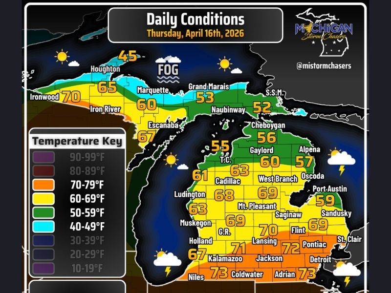
Thursday’s forecast revealed a dramatic temperature spread across the state. Across the Upper Peninsula, Houghton sits at just 45 degrees while Ironwood reaches 70 and Marquette climbs to 65, with fog affecting central Upper Peninsula communities near Grand Marais where temperatures hover in the low 50s.
Across the Lower Peninsula, temperatures warm considerably heading south. Cadillac reaches 63 degrees, Ludington climbs to 68, and Lansing tops out at 72 degrees. The warmest readings of the day are found along the southern tier, with Niles, Adrian, and the Detroit metro all reaching 73 degrees Thursday afternoon.
Ongoing Flooding Remains the Top Priority
Despite gradual weather improvement, Michigan’s flooding crisis continues demanding attention from residents and emergency crews statewide. Tornado damage assessments and flood monitoring are ongoing as officials work to evaluate the full extent of this week’s severe weather destruction.
Residents in flood-affected areas should continue avoiding any standing or moving water on roadways, as conditions can change rapidly and submerged road damage poses serious hidden hazards beneath floodwater.
Are you dealing with flooding or storm impacts across Michigan today? Share your experience and stay connected with our continuing coverage at SaludaStandard-Sentinel.com.