Thunderstorms to Fire Along I-5 Corridor Into Seattle and Puget Sound Late Tuesday as Pacific Low Approaches Oregon Coast Pushing Warm Unstable Air Into Western Washington
SEATTLE, WA — A wayward Pacific low pressure system tracking toward the Oregon coast is set to trigger thunderstorm development along the I-5 corridor into Western Washington, with storms expected to reach the Seattle and Puget Sound area during late Tuesday afternoon into Tuesday evening, while daytime highs climb unexpectedly into the upper 70s and potentially flirt with 80 degrees ahead of the approaching system.
Pacific Low Bringing Unstable Air Into Western Washington
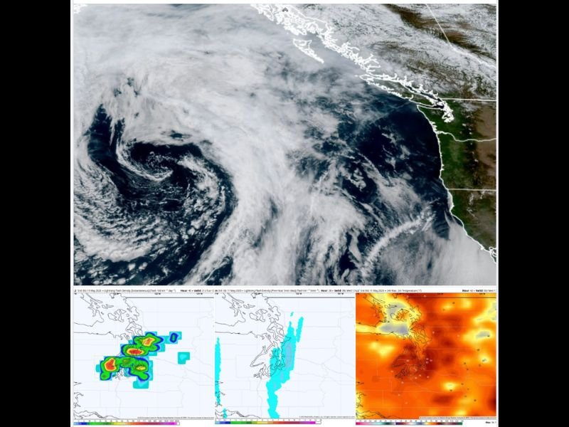
A low pressure system moving ashore along the Oregon coast late Tuesday is pulling warm, moist, and increasingly unstable air northward from the south into Western Washington. European model guidance has shifted the low’s landfall point northward to central Oregon, close enough that Western Washington will experience fringe effects from the storm system as the circulation draws unstable southerly air into the region during the afternoon and evening hours.
Earlier model projections had placed the low much further south near the Oregon-California border, but the northward shift increases the thunderstorm threat for the Seattle metro and surrounding Puget Sound communities.
Thunderstorms Possible Along I-5 Into Seattle Late Tuesday
Storms are expected to initially fire in western Oregon during Tuesday afternoon as the low approaches, before being pushed northward into Western Washington via the southerly flow along the I-5 corridor. Some models bring thunderstorms into the Puget Sound and Seattle area as early as late Tuesday afternoon into Tuesday evening, while other solutions favor an overnight timing into Wednesday morning.
Better storm chances exist across the southern and central Cascades and southern Washington, which sit closer to the low pressure center and will experience more direct forcing throughout the event.
Upper 70s Tuesday Before Pattern Change Brings Cooler Week
Daytime highs around Seattle are expected to reach the upper 70s and possibly touch 80 degrees Tuesday ahead of the approaching system, warmer than initially forecast due to the approaching low enhancing the ridge temporarily during the morning hours. However, behind the system, a significant pattern change will bring cooler and cloudier conditions through the remainder of the week with highs dropping into the upper 50s to low 60s, patches of drizzle, and additional rain chances particularly Friday into Saturday across the Pacific Northwest.
For continuing coverage of severe weather events and critical storm analysis across the United States, visit SaludaStandard-Sentinel.com.