Flash Flood Warnings and Over Four Inches of Rain Slam Alabama From York to Auburn as Tornado Watch Remains Active for South Alabama Until 6 AM CDT May 7, 2026
MONTGOMERY, AL — Flash flood warnings are in effect across a broad corridor of Alabama stretching from York and Livingston eastward to Auburn and Opelika just before midnight, as some locations within the warned zone have already recorded over four inches of rainfall, while a Tornado Watch simultaneously remains active across South Alabama until 6:00 AM CDT on Thursday, May 7, 2026.
Flash Flooding Now the Greatest Immediate Threat
Forecasters have identified flooding as the most pressing concern across Alabama heading into the midnight hours, with flash flood warnings blanketing a significant stretch of the state from the western border eastward through the Auburn and Opelika area. Several spots within this corridor have already absorbed more than four inches of rain throughout the day, pushing waterways, drainage systems, and low-lying roadways to or beyond their capacity.
Residents across York, Livingston, Auburn, Opelika, and all communities in between are urged to treat any standing or moving water on roadways as an extreme hazard and avoid all unnecessary travel until conditions improve.
Rain Covers Much of Alabama With Storms Below Severe Limits
Radar imagery captured just before midnight shows widespread rain coverage extending across much of Alabama, with heavy returns concentrated from the Birmingham and Tuscaloosa region southward through Montgomery and toward the Gulf Coast. Despite the significant rainfall totals and broad coverage, all storm cells are currently operating below severe weather thresholds.
Overall severe weather instability values are fading as the night progresses, meaning the tornado and wind threat is diminishing across most of the state even as rainfall continues to accumulate at dangerous levels across the hardest-hit zones.
Tornado Watch Active for South Alabama Until 6 AM
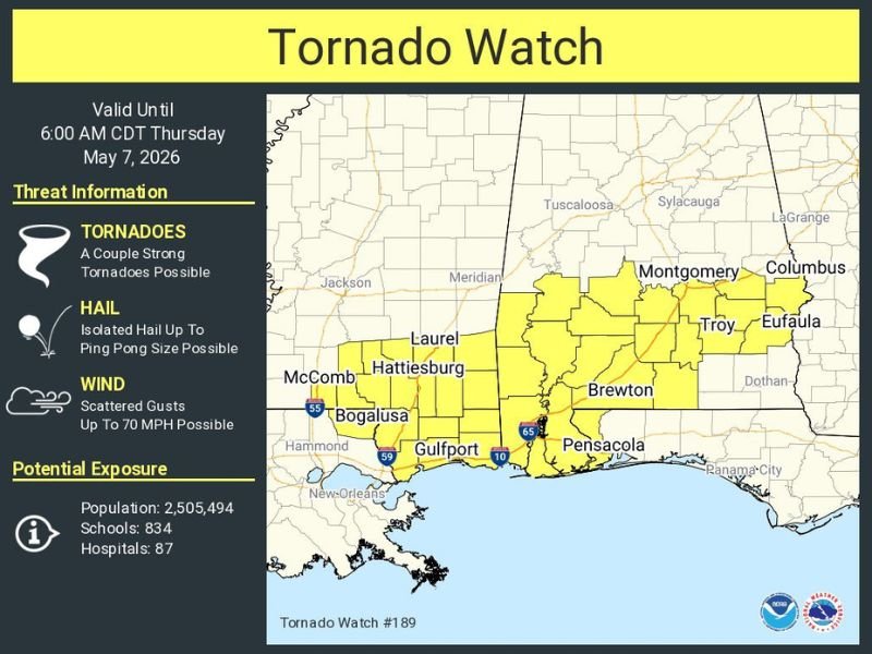
The Storm Prediction Center issued a Tornado Watch for South Alabama valid through 6:00 AM CDT Thursday, May 7, 2026, covering a swath of counties including Montgomery, Troy, Brewton, Eufaula, Dothan, and communities stretching toward the Gulf Coast near Pensacola. The watch carries a threat of a couple of strong tornadoes, isolated hail up to ping pong ball size, and scattered wind gusts up to 70 miles per hour.
The watch zone encompasses a population of approximately 2,505,494 residents and 834 schools, underscoring the significant human exposure within the active threat corridor across southern Alabama.
Residents Across South Alabama Urged to Remain Alert
Despite fading instability values reducing the overall severe threat, the active Tornado Watch demands continued vigilance from all residents across South Alabama through the early morning hours. Conditions can change rapidly overnight, and the combination of an active tornado watch and ongoing flash flood warnings creates a compounding hazard environment that requires heightened caution.
Residents are strongly advised to keep emergency alert systems active, avoid flooded roadways, and maintain shelter awareness until both the Tornado Watch and flash flood warnings fully expire across their specific locations.
For continuing coverage of severe weather events and critical storm analysis across the United States, visit SaludaStandard-Sentinel.com.