Temperatures Surging Into the 80s and Hitting 87 Degrees Across Northern Illinois and Southern Wisconsin by Monday as Summer Pattern Locks In Through May 13 to 19 With Storms Likely Weekend Into Next Week
NORTHERN ILLINOIS/SOUTHERN WISCONSIN — Summer is rapidly returning to the Northern Illinois and Southern Wisconsin Stateline region, with temperatures climbing into the 80s by Friday and reaching 87 degrees by Monday as the extended forecast through May 13 to 19 delivers a dramatic warm-up, though a brief cool swing Wednesday could bring patchy frost to outlying areas in what forecasters are calling the last frost mention until next fall.
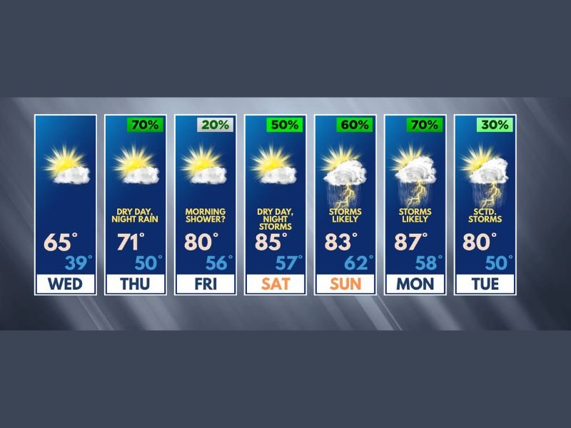
Wednesday Brings Last Frost Before Summer Takes Hold
Wednesday delivers a pleasant day with a high of 65 degrees, but Wednesday night carries the potential for patchy frost across outlying and rural locations as temperatures drop to 39 degrees overnight. Forecasters are emphatic that this represents the final frost mention for the region until next fall, after which cool air becomes essentially nonexistent for the foreseeable future across the Stateline area.
Residents with gardens or sensitive outdoor plants should take protective measures Wednesday night before the warming trend eliminates any further frost concerns through the season.
80s Return Friday With Gorgeous Conditions
After Thursday’s seasonable high of 71 degrees and overnight soaking rain carrying a 70 percent probability, Friday delivers a dramatic temperature surge to 80 degrees with only a possible morning shower lingering before gorgeous conditions take over. The return to the 80s marks the first time in several weeks that temperatures have reached this threshold across Northern Illinois and Southern Wisconsin, signaling the definitive arrival of summer warmth across the Stateline region.
Saturday maintains the warm pattern with a high of 85 degrees and a dry daytime before overnight storms return with a 50 percent probability during the evening hours.
Storms Likely Sunday and Monday as Heat Peaks at 87
The most active weather period of the extended forecast arrives Sunday through Monday, when storms are considered likely at 60 and 70 percent probability respectively as temperatures peak at 83 Sunday and 87 degrees Monday. While a few stronger storms are possible during this period, forecasters note it is too early to sound any severe weather alarm bells for the Stateline region at this time.
Tuesday rounds out the forecast with scattered storms at 30 percent and a high of 80 degrees as conditions begin a modest cooling trend into the following week.
For continuing coverage of severe weather events and critical storm analysis across the United States, visit SaludaStandard-Sentinel.com.