Summer Like Heat Building to Upper 80s This Weekend and Near 90 Degrees Early Next Week Across Alabama and the Southeast as Dry Drought Conditions Amplify the Warmth
ALABAMA — Summer-like heat is rapidly building across Alabama and the broader Southeast, with afternoon highs climbing into the mid to upper 80s by the weekend and some locations approaching 90 degrees during the early portion of next week, as dry and drought-affected conditions across the region amplify the warming trend driven by a returning south wind pattern.
Upper 80s Expected This Weekend With Sunshine
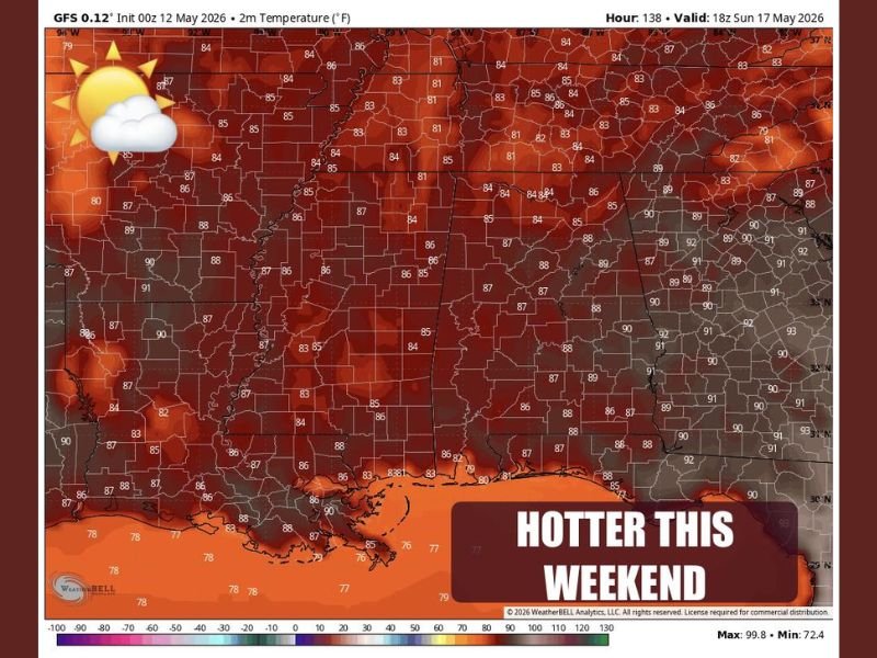
GFS model data initialized on May 12, 2026 and valid through Sunday May 17 shows widespread temperatures in the 85 to 92 degree range blanketing Alabama and surrounding Southeast states, confirming the significant warmth building into the weekend period. Afternoon highs rebounding into the mid to upper 80s by Saturday and Sunday will arrive alongside lots of sunshine and cool morning temperatures following a cold front passage mid-week, creating a classic late spring warm-up pattern across the region.
Today’s conditions feature partly to mostly sunny skies with east winds and highs in the upper 70s, representing the last of the more comfortable readings before the heat surge takes hold.
Wednesday Cold Front Brings Brief Break Before Heat Returns
A cold front arriving Wednesday will keep most of the region dry with only a stray shower possible and highs near 80 degrees as the boundary pushes through. Behind the front, cooler mornings will prevail heading into the weekend before afternoon temperatures rapidly rebound into the warming pattern that carries readings toward the upper 80s by Saturday and Sunday.
The front provides only a brief interruption to the overall warming trend rather than a sustained cool period across the Alabama and Southeast region.
Near 90 Degrees Possible Early Next Week
The most significant heat of the upcoming period arrives during the early portion of next week, when some spots across Alabama and the Southeast could approach or touch 90 degrees as a south wind returns and atmospheric instability increases across the region. Drought and abnormally dry conditions currently affecting the area will keep humidity levels sufficiently low to prevent heat index values from becoming dangerously extreme despite the high temperature readings.
The next chance for scattered showers and storms is expected around the middle of next week as the south wind pattern increases moisture return across the region.
For continuing coverage of severe weather events and critical storm analysis across the United States, visit SaludaStandard-Sentinel.com.