Soaking Rain and Heavy Downpours Target Wildfire-Stricken South Georgia With Rainfall Spreading Across Atlanta, Macon, Savannah, and Valdosta by 8 AM Saturday
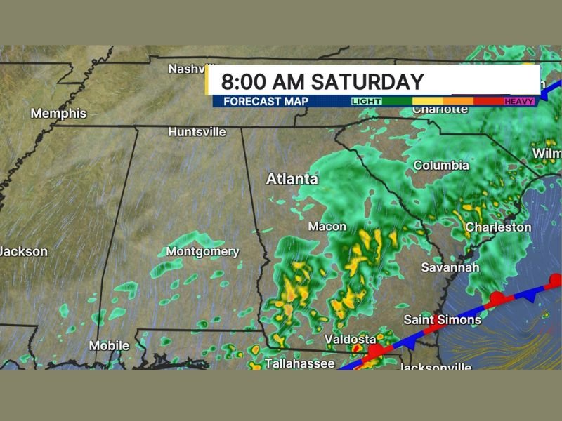
SOUTH GEORGIA, GA — A soaking and much-needed rain event was forecast to deliver heavy downpours across wildfire-stricken South Georgia by Saturday morning, with forecast map imagery valid at 8:00 AM Saturday showing widespread precipitation coverage pushing across Atlanta, Macon, Savannah, Valdosta, and the broader Georgia corridor as the rainfall system moved through the Southeast region.
The heaviest downpours were directed toward South Georgia, the area most desperately in need of significant rainfall relief following an extended period of dry and fire-prone conditions that had allowed wildfires to develop and spread across the region.
Heaviest Rain Targets South Georgia Wildfire Areas
The most significant rainfall from the Saturday system was forecast to concentrate across South Georgia, where ongoing wildfire conditions had created a critical need for substantial precipitation. The forecast map showed heavier yellow and orange precipitation returns pushing through the Valdosta corridor and southward toward Tallahassee and Jacksonville, indicating the presence of heavy downpour activity across the communities most affected by the dry and fire-dangerous conditions of recent weeks.
While the rest of Georgia and surrounding states received light to moderate rainfall from the system, South Georgia stood to benefit most from the concentrated downpour activity tracking through the region Saturday morning.
Widespread Rain Covers Atlanta, Macon, and Coastal Georgia
Beyond the heavy downpour focus across South Georgia, widespread light to moderate rainfall covered an enormous geographic area across the broader Southeast region. Forecast imagery showed green precipitation returns blanketing Atlanta, Macon, Columbia, Charleston, Savannah, Saint Simons, and extending northward through Charlotte and the Carolinas as the rain system pushed through the region during the Saturday morning hours.
The broad coverage of the rainfall event delivered beneficial precipitation across a wide swath of the drought-affected Southeast, with communities from Huntsville and Montgomery in the west through the full Georgia and South Carolina corridor receiving meaningful rainfall accumulations from the Saturday system.
Wildfire Relief Rainfall Arrives at a Critical Time
The arrival of soaking rain across wildfire-stricken South Georgia came at a critically important time for communities and firefighting efforts dealing with the ongoing fire conditions across the region. Significant rainfall events represent the most effective natural mechanism for suppressing active wildfires and reducing the dangerous fire weather conditions that allow new ignitions to develop and spread rapidly across dry vegetation.
The combination of heavy downpours directly targeting the South Georgia wildfire areas and widespread moderate rainfall across the broader Southeast region made the Saturday morning precipitation event one of the most consequential and welcomed weather developments for the region in recent weeks.
For continuing coverage of weather events and critical storm analysis across the United States, visit SaludaStandard-Sentinel.com.