Heavy Rainfall Totals Up to 5 Inches Threatening Mississippi Alabama and Louisiana Through Thursday as Frontal Line Mixes With Tropical Moisture Bringing Isolated Flooding Risk
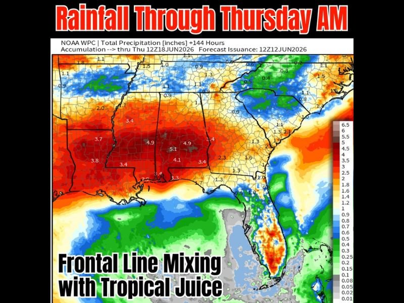
JACKSON, MS — A significant rainfall event is taking shape across the central Gulf Coast states through Thursday morning, June 18, with NOAA WPC 144-hour total precipitation forecasts issued June 12 showing accumulations of 4 to 5 inches across Mississippi, Alabama, and Louisiana as a stalled frontal line combines with tropical moisture from Pacific system Cristina to produce an extended period of heavy rainfall and isolated flooding potential across the region.
Where the Heaviest Rain Falls
The NOAA WPC total precipitation map through Thursday at 12Z June 18 depicts the most extreme rainfall accumulations concentrated across central and southern Mississippi and central Alabama. Core totals of 4.9 to 5.1 inches are forecast across the heart of Mississippi, with widespread 3.4 to 4.9 inch totals blanketing the majority of the state from north to south.
Alabama shows similarly impressive totals, with central portions of the state forecast to accumulate 3.4 to 4.9 inches through the period. Louisiana’s eastern parishes are also in the 3.4 to 3.8 inch range, while coastal areas near the mouth of the Mississippi River could see localized totals approaching 7 inches in the most active rainfall corridors.
What’s Driving the Heavy Rain
Two primary factors are combining to produce this rainfall event. A frontal line is expected to dip southward this weekend and stall across the upper Gulf Coast through midweek, acting as a persistent focus for shower and thunderstorm development across the same general area day after day.
Simultaneously, tropical moisture associated with Pacific system Cristina — monitored by the National Hurricane Center — is being drawn northward into the frontal zone, significantly enhancing available precipitable water values and boosting rainfall totals well above what the frontal boundary alone would produce. This tropical juice infusion is the primary reason some locations could see 5 or more inches of total accumulation through Thursday morning.
Flooding Concern
With 4 to 5 inch rainfall totals spread across multiple days of repeated storm activity over the same areas, isolated flooding is a genuine concern across Mississippi and Alabama — particularly in low-lying river corridors, agricultural areas with saturated soils, and urban zones with limited drainage capacity.
Residents across central Mississippi and Alabama should monitor National Weather Service flood advisories closely through the coming week. For continuing coverage of Gulf Coast rainfall and flooding threats across the United States, visit SaludaStandard-Sentinel.com.