Severe Weather Window Moved Up to 7PM Through 1AM Across Northwest Ohio as Multiple Storm Zones Track Through the Region Wednesday Evening
TOLEDO, OH — The severe weather timing for northwest Ohio has been moved up by several hours Wednesday, with the primary threat window now running from 7 p.m. through 1 a.m. as a warm front position becomes the critical factor determining exactly where the most intense storms develop, with areas near or south of the front facing a rapidly increasing threat while communities to the north see significantly lower severe weather risk.
The Warm Front Factor
The single most important atmospheric feature for Wednesday’s severe weather setup across northwest Ohio is the position of a warm front stalling during the afternoon and evening hours. An early-day thunderstorm complex will be the biggest driver of exactly where that warm front parks later today — a factor that introduces meaningful uncertainty into the precise placement of the highest-threat zone.
North of the warm front, the severe weather threat drops significantly. Near and south of the front, the threat increases rapidly, placing communities along that boundary in the highest risk corridor for Wednesday’s event.
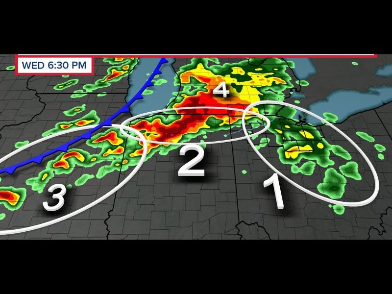
Four Storm Zones Identified
WTOL 11 Weather Impact hour-by-hour radar simulation valid Wednesday at 6:30 p.m. identifies four distinct storm zones across the northwest Ohio region. Zone 4 — depicted with intense red and orange cores in the northern portion of the frame — represents the most active storm area at that timeframe, with deep reflectivity indicating the heaviest and most organized convection. Zones 1 and 2 show additional storm clusters across the central and eastern portions of the region, with Zone 3 representing a separate area of storm activity to the southwest.
The multiple zone structure reflects the complex and multi-faceted nature of Wednesday’s severe weather setup, where different storm modes and clusters will be operating across overlapping areas simultaneously through the evening hours.
Timing Adjusted to Evening Hours
With the severe weather window now starting at 7 p.m. rather than the originally anticipated timeframe, residents across northwest Ohio have additional preparation time through the afternoon. However, the 7 p.m. to 1 a.m. window demands that anyone with evening outdoor plans build in contingencies and have a shelter plan finalized before dinnertime.
Weather alert systems should remain active through the entire overnight period given the 1 a.m. end of the primary threat window.
For continuing coverage of northwest Ohio severe weather across the United States, visit SaludaStandard-Sentinel.com.