Severe Weather Possible Across Illinois and Missouri Monday With Tornadoes, Large Hail and Damaging Winds Expected as Major Storm System Moves In
ILLINOIS — Monday, April 27, 2026 is shaping up to be a day forecasters are watching very closely across Illinois and Missouri. The latest guidance shows a strong storm system lifting northward into Iowa with a trailing cold front draped across the state, setting the stage for a potentially significant severe weather event with all modes of severe weather considered possible across the region.
The event is currently expected to be a daytime occurrence, with storm activity moving out of the region by sunset, giving residents a relatively defined window to monitor and prepare for.
What Is Driving Monday’s Severe Weather Setup
The cold front pushing into the region will usher in a very warm, moist, and unstable air mass across Illinois and Missouri ahead of it. A warm front will also be draped across the state simultaneously, increasing wind shear and causing directional changes with height that are favorable for rotating thunderstorm development.
The combination of these two boundaries converging across the same region on the same day creates the kind of complex and potentially dangerous setup that forecasters say supports all modes of severe weather, including tornadoes, large hail, and damaging straight-line winds.
Where the Warm Front Falls Will Determine the Highest Risk
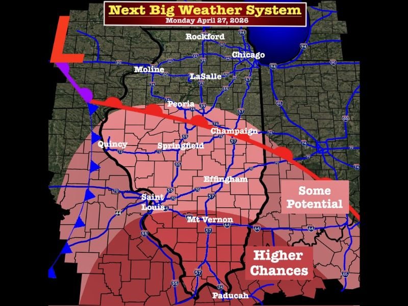
The exact position of the warm front on Monday will be the critical factor in determining which communities face the greatest severe weather potential. Current guidance places the warm front near the Interstate 72 corridor, which runs through communities including Springfield, Champaign, and Decatur.
Areas north of the warm front are expected to carry a higher hail risk, while areas along and south of the warm front face a more elevated tornado risk. However, forecasters note the warm front could shift northward, which would expand the tornado risk zone further north across the state.
Primary Threat Zone Covers Central and Southern Illinois
The forecast map identifies two distinct risk zones for Monday. The higher chance area covers central and southern Illinois including Springfield, Peoria, Effingham, Mt. Vernon, and Paducah, along with portions of Missouri near Saint Louis. This zone sits within the deepest and most unstable portion of the air mass where storm development is most favored.
A secondary zone of some potential extends further north and east, covering communities including Rockford, Chicago, Moline, LaSalle, and Champaign, where severe weather is possible but less certain depending on warm front placement.
Timing and Resident Preparedness
The event is leaning toward a daytime timeline, with storms expected to develop during the afternoon hours and move out of the region by sunset. Residents across Illinois and Missouri should have their severe weather plans finalized before Monday afternoon arrives and stay connected to updated local forecasts throughout the day as guidance continues to improve.
Are you tracking Monday’s severe weather threat across Illinois and Missouri? Share your preparations and stay informed with the latest coverage at SaludaStandard-Sentinel.com.