Severe Thunderstorms Large Hail and Heavy Snow Strike Colorado Sunday With Storms Developing by Noon Along the I-25 Corridor and Rain Snow Mix Expected Overnight Into Monday Morning
DENVER, CO — A significant and multi-phased storm timeline is set to impact Colorado on Sunday, May 17, 2026, bringing severe thunderstorms, large hail, damaging winds, and heavy mountain snow across multiple regions of the state. The Denver and Front Range corridor faces the most active window of the event, with storm development expected by noon before conditions transition to rain and snow overnight into Monday morning.
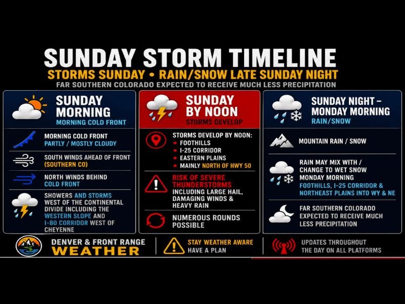
Sunday Morning Cold Front Brings Clouds and Early Showers West of the Divide
Sunday begins with a morning cold front pushing through the region, producing partly to mostly cloudy skies across Colorado. South winds ahead of the front across southern Colorado will shift to north winds behind the cold front as it progresses through the state during the morning hours. Showers and storms are already expected west of the Continental Divide, including across the Western Slope and along the I-80 corridor west of Cheyenne during the morning timeframe.
Far southern Colorado is expected to receive considerably less precipitation throughout the entire Sunday event, with most of the significant weather activity staying north and east of that region as the storm system tracks through.
Severe Thunderstorms Develop by Noon Across the Foothills I-25 Corridor and Eastern Plains
By noon on Sunday, storms are forecast to develop across the Foothills, the I-25 corridor, the Eastern Plains, and mainly north of Highway 50. This midday convective initiation carries a risk of severe thunderstorms capable of producing large hail, damaging winds, and heavy rainfall across the affected zones. Multiple rounds of storms are possible through the afternoon hours as the unstable airmass interacts with the advancing frontal boundary across the Front Range.
The I-25 corridor from Denver southward through the Front Range communities sits directly within the primary storm development zone, making this a particularly impactful period for one of Colorado’s most densely populated regions during the Sunday afternoon timeframe.
Sunday Night Into Monday Morning Brings Rain Snow Mix Across the Mountains and Plains
As Sunday transitions into the overnight hours, the storm threat gradually shifts toward a rain and snow pattern across multiple zones. Mountain rain and snow will develop across higher elevations, while rain may mix with and change to wet snow by Monday morning across the Foothills, the I-25 corridor, and the Northeast Plains extending into Wyoming and Nebraska.
The overnight transition from thunderstorms to wintry precipitation reflects the dynamic and rapidly changing nature of this multi-phased Colorado storm system as colder air wraps in behind the departing cold front through the early Monday morning hours.
Residents Urged to Stay Weather Aware and Have a Plan Throughout the Day
Given the multiple distinct hazard types expected across different regions and timeframes throughout Sunday, Colorado residents are strongly encouraged to stay weather aware and have a clear severe weather plan in place before the day begins. Outdoor plans should account for the deteriorating conditions expected by noon, with the storm threat arriving quickly once convection initiates along the Front Range.
Updates to the forecast are expected throughout the day as the system evolves, and residents across the Denver and Front Range area are urged to monitor all available platforms for the latest information as Sunday’s complex storm timeline unfolds.
For continuing coverage of severe weather events and storm forecasts across the United States, visit SaludaStandard-Sentinel.com.