Storm Complex Develops Across South Central Texas Tuesday Night Moving East Through San Antonio Austin and New Braunfels Corridor With Heavy Rain Expected by Wednesday Midnight
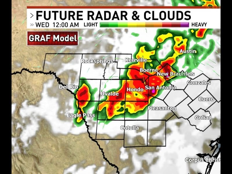
SAN ANTONIO, TX — A storm complex is forecast to develop across south central Texas during Tuesday night and move eastward through the overnight hours, with GRAF model future radar valid for Wednesday at 12:00 AM showing intense red and orange reflectivity returns concentrated across a broad corridor stretching from the Del Rio and Eagle Pass area northeastward through Uvalde, Hondo, San Antonio, Boerne, New Braunfels, and toward the Austin metropolitan area.
GRAF Model Shows Intense Storm Complex Developing From Del Rio Through San Antonio
The GRAF model future radar imagery at Wednesday midnight depicts a well organized and expansive storm complex covering a large portion of south central Texas, with the heaviest storm cores concentrated along a northeast oriented band from the Del Rio and Uvalde corridor through Hondo and into the San Antonio metropolitan area. Deep red and orange reflectivity returns within the forecast storm complex indicate the potential for heavy rainfall rates and organized convective activity as the system develops and moves eastward through the overnight hours across the south Texas Hill Country and surrounding regions.
The storm complex’s development from the Del Rio and Eagle Pass area suggests an influx of moisture from the southwest driving the convective initiation before the organized system pushes northeast toward more populated areas through the late night hours.
Austin New Braunfels and Kerrville Also in the Path of the Overnight Storm Movement
The northeastern extent of the forecast storm complex places Austin, New Braunfels, Kerrville, and Boerne within the path of the developing overnight system as it moves east through south central Texas by the Wednesday midnight timeframe. These communities along the I-35 corridor and the Texas Hill Country will need to monitor the storm complex’s progression through the overnight period as heavy rainfall and active convection push through the region during the late Tuesday night and early Wednesday morning hours.
Residents Across South Central Texas Urged to Stay Weather Aware Overnight
All residents across the affected south central Texas corridor from Del Rio and Uvalde through San Antonio and northward toward Austin are encouraged to remain weather aware through Tuesday night and into early Wednesday morning as the storm complex develops and moves east. Heavy rainfall remains the primary concern with this overnight system as the organized convective complex tracks through the region.
For continuing coverage of storm forecasts and overnight weather tracking across the United States, visit SaludaStandard-Sentinel.com.