Active Severe Weather Day Threatens Western and Central Pennsylvania Sunday With 60 MPH Winds and Brief Spin Up Tornadoes Possible From Pittsburgh to Williamsport
PITTSBURGH, PA — One of the most active severe weather days in recent memory is shaping up across western and central Pennsylvania on Sunday, with recent model guidance showing the potential for multicell storm segments and squall lines capable of producing winds exceeding 60 mph and brief, spin-up tornadoes across a broad corridor stretching from Pittsburgh through State College and toward Williamsport.
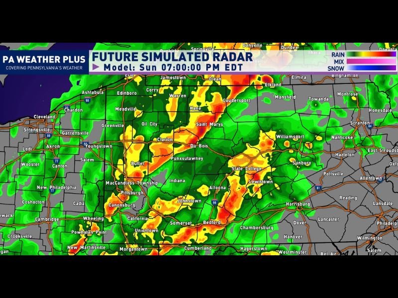
What the Future Radar Shows
PA Weather Plus future simulated radar modeling valid Sunday at 7:00 p.m. EDT depicts an extensive area of intense storm activity covering much of western and central Pennsylvania. The most severe-looking returns — shown in deep red and orange — are concentrated across a corridor running from Du Bois and Punxsutawney through State College, Lewistown, and toward Altoona and Johnstown, with additional intense cells near Pittsburgh, Butler, and the Indiana County area.
Northern Pennsylvania communities including Warren, Kane, and Coudersport also show significant activity on the future radar, with green and yellow returns extending across much of the Allegheny Plateau region. The widespread coverage on this simulation reflects the multicell and squall line storm mode forecasters are anticipating for the event.
Primary Hazards
The combination of multicell storm segments and squall lines moving through the region creates conditions favorable for widespread damaging winds, with gusts of 60 mph or greater possible within the strongest cells. Additionally, brief spin-up tornadoes are a risk within this type of storm environment, where embedded circulations can develop rapidly along the leading edge of squall lines with little advance warning.
The Nature of Summertime Convection
Forecasters emphasized an important reality about Sunday’s setup: not every location across the risk area will experience severe weather or even meaningful rainfall. Summertime convection of this type can produce dramatically different outcomes within just a few miles — one neighborhood could see tornadoes and damaging winds while an area five miles away experiences only light rain. A location seeing nothing does not mean the overall forecast was wrong.
What Residents Should Do
Anyone with outdoor plans across western and central Pennsylvania Sunday should ensure they have reliable methods of receiving severe weather alerts and a safety plan ready in case warnings are issued for their specific location. All warnings should be heeded seriously regardless of current local conditions. For continuing coverage of Pennsylvania severe weather across the United States, visit SaludaStandard-Sentinel.com.