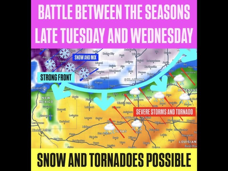
Severe Storms Tornadoes and Snow Possible Simultaneously Across Southern Plains as Strong Front Triggers Dramatic Battle Between Seasons Late Tuesday and Wednesday
SOUTHERN PLAINS — A dramatic battle between seasons was forecast to unfold across the Southern Plains late Tuesday and into Wednesday, as a strong cold front delivered simultaneous snow and mix conditions across the Oklahoma and Kansas Panhandles while severe storms and tornadoes threatened Texas, Oklahoma, and Arkansas on the warm side of the boundary.
The weather setup created a stark and extreme contrast across the region, with communities on opposite sides of the front experiencing conditions that felt worlds apart despite being separated by relatively short distances across the Southern Plains corridor.
Snow and Mix Blankets the Northern Zone
On the cold side of the strong front, snow and mixed precipitation was expected to push into the Oklahoma and Kansas Panhandles, Liberal, Dodge City, Guyman, Canadian, and surrounding high plains communities. Areas including Trinidad, Boise City, and Lamar in the Colorado and New Mexico border region also fell within the snow and mix zone as cold air surging behind the front drove wintry conditions across the northern tier of the Southern Plains.
The snow and mix threat added a late-season winter element to what was simultaneously shaping up as a significant severe weather outbreak directly to the south and east.
Severe Storms and Tornadoes Target Texas and Oklahoma
On the warm and unstable side of the front, severe storms and tornado potential threatened a broad corridor stretching from Wichita Falls, Lawton, and Ardmore through Dallas, Fort Worth, Waco, and into Arkansas communities including Mena and surrounding areas. The collision of the strong front with warm and humid Gulf air created classic severe weather ingredients across the Texas and Oklahoma corridor.
The extreme contrast between snow to the north and tornado-capable storms to the south within the same weather system underscored the extraordinary atmospheric energy accompanying the late Tuesday and Wednesday front across the Southern Plains.
Drastic Temperature Swings Define the Event
The temperature gradient across the front was expected to produce some of the most dramatic side-by-side weather contrasts possible, with communities north and west of the boundary experiencing cold, wintry conditions while areas south and east baked in the warm and unstable air mass supporting severe storm development. Residents across the full Southern Plains corridor were advised to know which side of the front their community fell on and prepare accordingly for either wintry mix or severe storm hazards through the Tuesday and Wednesday timeframe.
For continuing coverage of weather events and critical storm analysis across the United States, visit SaludaStandard-Sentinel.com.