Significant Storm Threat With Likely Storms and Decent Rainfall Returns by Wednesday May 6 After Several Dry and Comfortable Days Across the Region
THE SOUTH — A few quiet, dry, and comfortable days were forecast ahead before a significant weather threat returned by Wednesday, May 6, with storms considered likely and meaningful rainfall expected through Thursday, May 7, as ECMWF model data showed substantial moisture pushing into the region and total precipitation accumulations spreading across a broad geographic footprint through the mid-week period.
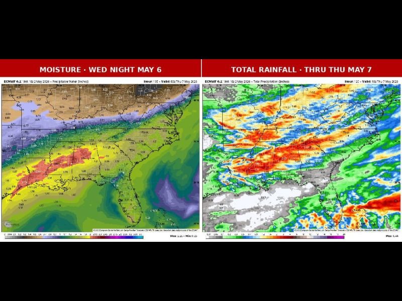
ECMWF moisture imagery valid Wednesday night May 6 showed a well-defined surge of precipitable water pushing into the Southeast and Mid-South corridor, with the highest moisture values concentrated across the Gulf Coast states and extending northward through the central and eastern United States ahead of the approaching storm system.
Storms Likely But Key Details Still Uncertain
While storms were confirmed as likely for the Wednesday event, several critical forecast details remained unresolved at the time of the update. Precise timing of the storm arrival, the tornado potential, and which specific communities would face the greatest risk were all still being evaluated as forecast models worked toward a clearer solution heading into the midweek period.
Total rainfall imagery through Thursday May 7 showed significant precipitation accumulations across a wide area, with the heaviest rainfall depicted across portions of the Southeast and Mid-South in deep red and orange tones indicating the most substantial totals expected from the Wednesday through Thursday event.
Dry and Comfortable Days Offer a Brief Welcome Break
Before the Wednesday storm system arrived, the region was set to enjoy several days of dry and comfortable conditions following the active and unsettled weather pattern of recent weeks. The brief quiet stretch offered residents an opportunity to recover from storm fatigue before the next round of significant weather required attention.
Residents across the region were encouraged to enjoy the quiet days ahead while staying tuned to updated forecasts as the Wednesday storm system came into sharper focus over the coming days. Monitoring trusted local weather sources as the event approached represented the best preparation strategy given the remaining uncertainty around timing and tornado potential through the mid-week severe weather window.
For continuing coverage of weather events and critical storm analysis across the United States, visit SaludaStandard-Sentinel.com.