Scattered Showers and Isolated Thunderstorms Continue Across North Carolina Saturday Night With More Showers and Storms Expected to Return Sunday Morning Through Evening
RALEIGH, NC — Scattered showers and an isolated thunderstorm are continuing across North Carolina at 11:08 PM Saturday, setting the theme for the remainder of the overnight hours as residual moisture keeps shower activity alive across portions of the state. Sunday will bring another round of scattered showers in the morning followed by a warmer afternoon and evening period that once again carries the potential for scattered showers and thunderstorms to develop across the state as daytime heating returns to the region.
Scattered Showers and Isolated Thunderstorm Activity Persist Across the State at 11 PM
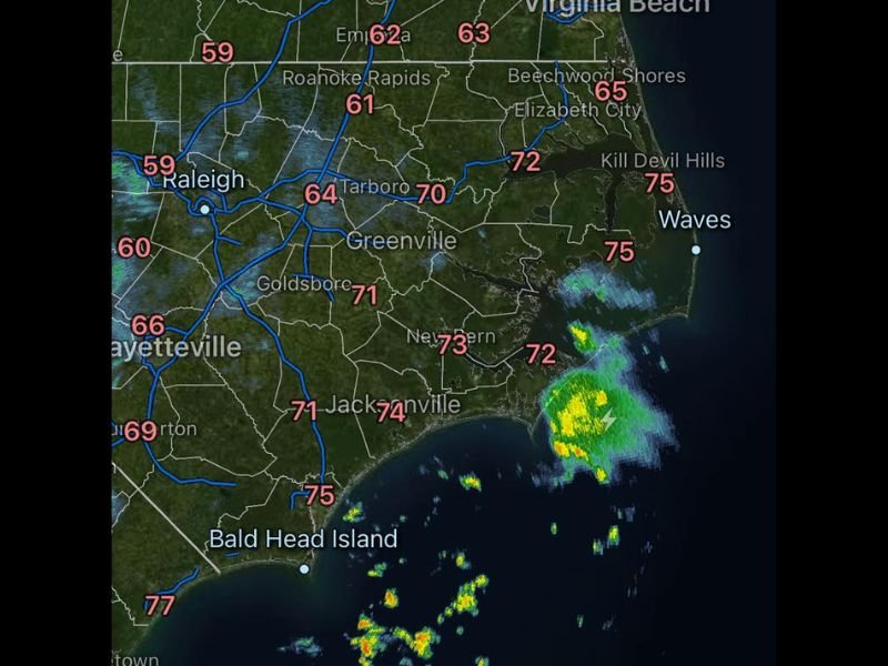
Radar imagery at 11:08 PM shows scattered shower returns across multiple portions of North Carolina, with the most organized activity visible along the coastal plain near Jacksonville, New Bern, and the Outer Banks corridor where temperatures are sitting in the lower to mid 70s. Additional scattered shower returns are visible across the northern piedmont near the Virginia border and along portions of the central coast, with the overall storm coverage remaining limited and scattered rather than widespread through the late Saturday night period.
Temperatures across the state at observation time range from the lower 60s across the northern piedmont and Roanoke Rapids area to the mid 70s along the southern coastal communities, reflecting the warm and moisture laden airmass continuing to support overnight shower development.
Sunday Morning Brings Scattered Showers Before a Warmer and More Active Afternoon
Sunday across North Carolina begins with scattered morning shower activity expected across the state, with the potential for an isolated thunderstorm mixed in among the shower coverage during the morning hours. Conditions are forecast to trend warmer statewide through Sunday compared to the cooler Saturday pattern, with the increased warmth providing additional instability to fuel another round of scattered shower and thunderstorm development through the afternoon and evening hours.
The Sunday afternoon and evening storm window represents the more significant weather concern of the day compared to the morning shower activity, as daytime heating combines with available atmospheric moisture to support more organized convective development across the North Carolina piedmont and coastal plain through the peak heating hours.
Statewide Weather Pattern Remains Active Through the Sunday Evening Hours
The overall weather pattern across North Carolina through the Sunday evening period reflects a persistently unsettled atmospheric setup that will keep shower and storm chances alive across the state through the holiday weekend. While neither the overnight activity nor Sunday’s storm chances represent a significant or organized severe weather threat, residents across all regions of North Carolina are encouraged to remain weather aware through Sunday afternoon and evening as the scattered storm pattern continues across the state.
For continuing coverage of weekend weather forecasts and storm tracking across the United States, visit SaludaStandard-Sentinel.com.