Flash Flooding Threat Surges Across North Texas Sunday Into Monday as Rainfall Rates Hit 2 Inches Per Hour and a Stalling Front Targets Dallas Tyler and Killeen
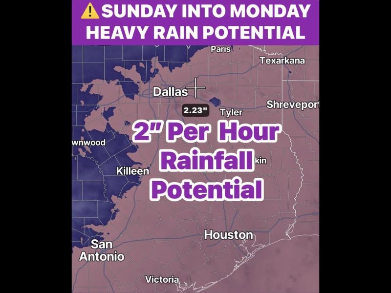
DALLAS, TX — A significant heavy rainfall and flash flooding event is developing across North Texas from Sunday into Monday, June 15, with rainfall rates capable of reaching 2 inches per hour, widespread rain chances of 60 to 90% across the region, and a cold front stalling south of Interstate 20 Sunday night before lifting back north Monday — extending the heavy rain threat across Dallas, Tyler, Killeen, and surrounding communities through the early week.
What’s Driving the Heavy Rain
Outflow boundaries surging south out of Oklahoma on Sunday will interact with a cold front pushing into North Texas, allowing daytime heating and a weakening atmospheric cap to trigger widespread shower and thunderstorm development through the afternoon. Low-level dry air beneath the storm bases will support strong downburst winds within the more intense cells, and a few storms could reach severe criteria with gusty winds as the primary hazard.
The atmosphere is forecast to be highly efficient at producing rainfall, with rates up to 2 inches per hour possible within the strongest storm cores. Any cell that remains stationary over one area for an extended period carries the potential to dump torrential rainfall and trigger localized flash flooding rapidly.
The Overnight and Monday Extension
The front is expected to stall south of I-20 Sunday night rather than pushing cleanly through the region, setting up an additional round of heavy showers and thunderstorms through the overnight hours and into Monday morning. This stalling mechanism is the primary flash flooding concern, as training storms repeatedly moving over the same locations could produce multi-inch rainfall totals well beyond what any single storm event would deliver.
Flash flooding may become a significant concern where repeated rounds of heavy rain track over the same corridors Sunday night into early Monday.
Temperature and Rain Coverage
Cloud cover and rain-cooled air will keep North Texas temperatures well below normal through the event, with highs holding mainly in the 80s — approximately 10 degrees cooler than typical mid-June values across the region. Rain chances ranging from 60 to 90% mean widespread measurable rainfall is expected across most of the area, with Dallas forecast to see approximately 2.23 inches of accumulation through the period.
Residents across Dallas, Tyler, Killeen, and the broader North Texas region should avoid flood-prone areas and never attempt to drive through flooded roadways Sunday through Monday. For continuing coverage of Texas flooding and severe weather across the United States, visit SaludaStandard-Sentinel.com.