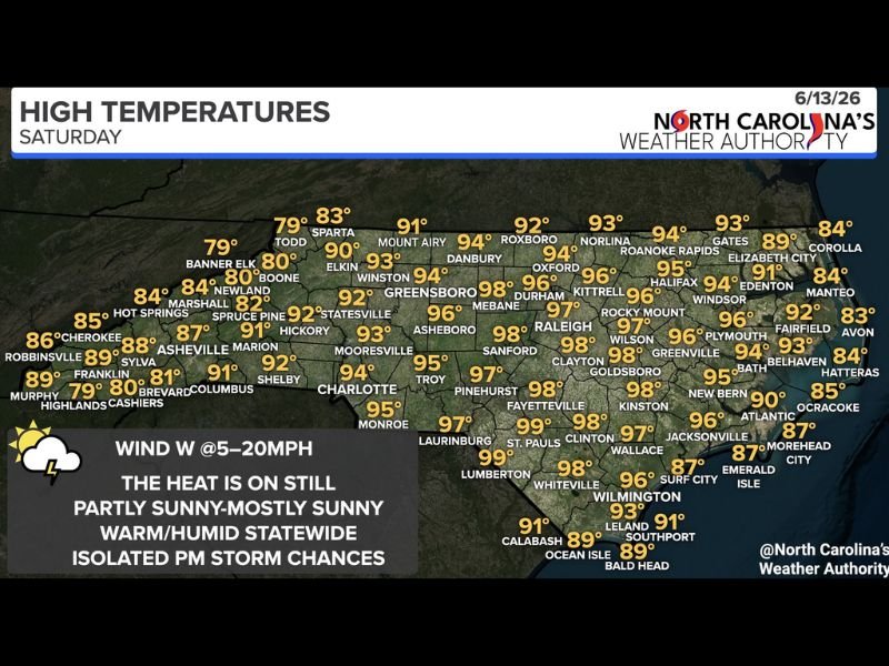
Intense Heat and Humidity Baking North Carolina Saturday With Highs Reaching 99 Degrees Across Central and Eastern Areas and Hit or Miss Storms Developing Along the Coast
RALEIGH, NC — Another dangerously hot and humid Saturday is gripping North Carolina on June 13, with high temperatures soaring into the upper 90s across central and eastern portions of the state, partly to mostly sunny skies accelerating afternoon heating, and hit or miss shower and thunderstorm chances developing along eastern and coastal sections through the evening hours.
Statewide Temperature Breakdown
North Carolina’s Weather Authority high temperature data for Saturday shows the most extreme heat concentrated across the central and eastern Piedmont corridor. Laurinburg tops out at 99°F while St. Pauls, Fayetteville, and Lumberton all reach 98 to 99°F. Raleigh climbs to 97°F, with Durham at 97°F, Mebane reaching 98°F, and Kittrell hitting 96°F across the Research Triangle region.
Further east, Kinston and Goldsboro reach 98°F while Wilson and Rocky Mount climb to 96 to 97°F. Charlotte tops out at 94°F and Greensboro reaches 94°F across the Piedmont. Mountain communities offer the only meaningful relief, with Boone holding at 80°F, Banner Elk at 79°F, and Murphy at 89°F through the afternoon.
Coastal communities including Wilmington reach 93°F, with the Outer Banks from Corolla through Hatteras staying in the mid to upper 80s thanks to sea breeze influence providing modest relief along the shoreline.
Humidity and Heat Index
With dew points remaining elevated statewide and westerly winds at 5 to 20 mph continuing to transport warm and humid air across the region, heat index values across central and eastern North Carolina will push well above the already extreme air temperatures during peak afternoon hours. Residents spending extended time outdoors during the 1 to 6 p.m. window face a genuine risk of heat-related illness without adequate hydration and shade.
Evening Storm Chances
Afternoon and evening shower and thunderstorm development is expected along eastern and coastal sections of the state as sea breeze boundaries interact with the deeply unstable airmass. Coverage will be hit or miss, meaning storm impacts will be localized rather than widespread, but any cell that develops could produce brief heavy rainfall and gusty winds.
Residents across eastern North Carolina and the coastal plain should keep weather alerts active Saturday evening.
For continuing coverage of North Carolina heat and storm threats across the United States, visit SaludaStandard-Sentinel.com.