Rare and Vivid Mammatus Cloud Display Captured Over Centerton Arkansas as Large Hail and Strong Winds Strike Fort Smith and Van Buren During Overnight Storm Passage
CENTERTON, AR — One of the most vivid and visually striking mammatus cloud displays witnessed over Arkansas in recent memory was captured over Centerton as a powerful storm system moved through the state overnight, while the worst of the severe weather concentrated to the south near Fort Smith and Van Buren where large hail and strong winds caused damage across those communities.
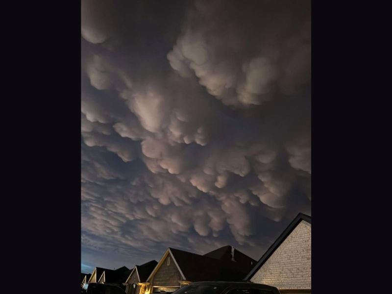
Stunning Mammatus Cloud Display Over Centerton
The skies over Centerton, Arkansas produced a remarkable and rare mammatus cloud formation as storms pushed through the region, delivering one of the more extraordinary natural weather spectacles documented over the state in a considerable period of time. The imagery shows hundreds of distinctive pouch-shaped cloud formations hanging downward from the base of the storm’s anvil cloud, covering the entire visible sky in a dramatic and almost surreal display of atmospheric activity directly overhead.
Mammatus clouds form on the underside of cumulonimbus anvil clouds when pockets of cold, moist air sink downward into drier surrounding air, creating the signature bulging formations that have made them one of the most visually compelling and widely photographed weather phenomena associated with severe thunderstorm systems.
What Mammatus Clouds Signal About Storm Intensity
The presence of a vivid and well-defined mammatus display directly over Centerton serves as a clear visual indicator of the extreme energy present within the storm system moving through Arkansas that evening. While mammatus clouds themselves do not produce severe weather, their appearance is strongly associated with powerful supercell thunderstorms and indicates that the parent storm system contains the kind of intense updraft and anvil structure characteristic of the most energetic severe weather events.
The exceptional clarity and density of the formations captured over Centerton reflect a storm system of considerable atmospheric power moving across the Arkansas region during the overnight hours.
Large Hail and Strong Winds Hit Fort Smith and Van Buren
While Centerton experienced the dramatic overhead cloud display, the most destructive elements of the storm system were concentrated further south near Fort Smith and Van Buren, where large hail and strong winds impacted both communities during the storm’s passage. These threats represent the most damaging severe weather outcomes associated with the overnight system across western Arkansas, with hail capable of damaging vehicles, structures, and vegetation across the affected areas.
Residents across Fort Smith, Van Buren, and surrounding communities in the River Valley region are advised to assess any hail or wind damage to their properties in the aftermath of the overnight storm system.
For continuing coverage of severe weather events and critical storm analysis across the United States, visit SaludaStandard-Sentinel.com.