Rains Sweeping Across Northwest Georgia Saturday Night Targeting Chattanooga, Dalton, and LaFayette as Cooler Weather Arrives Sunday
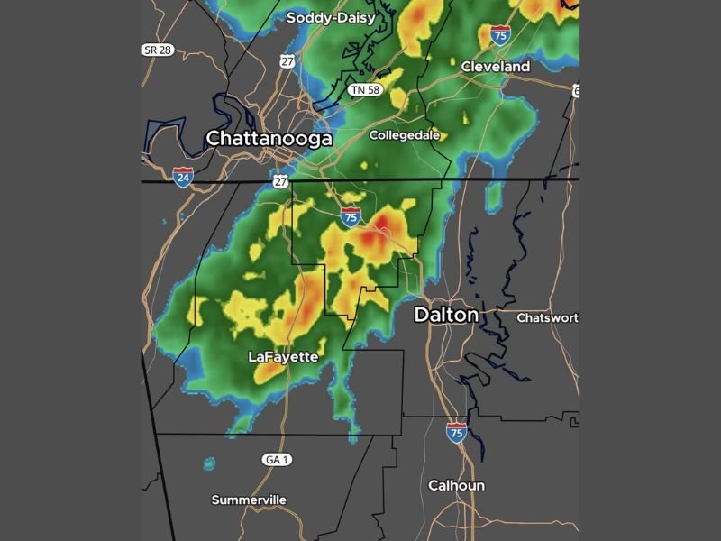
NORTHWEST GEORGIA — A radar snapshot captured at 9:47 PM Eastern Saturday, April 18, 2026, showed a decent area of rainfall sweeping across northwest Georgia, delivering much needed precipitation to communities including Chattanooga, Dalton, LaFayette, and Collegedale. Meteorologist Greg Majewski confirmed the rain line is losing its punch as expected from model guidance, with cooler and drier conditions set to arrive across the region by Sunday.
The heaviest rainfall cores were concentrated along the Interstate 75 corridor between Chattanooga and Dalton, where orange and red radar returns indicated more intense rainfall rates pushing through the area during the late Saturday evening hours.
Heaviest Rain Concentrated Along I-75 Corridor
Radar imagery showed the most intense rainfall activity positioned along the Interstate 75 corridor stretching from Chattanooga southward through Dalton. The deepest radar returns showing orange and red reflectivity values were concentrated in this zone, indicating rainfall rates significantly higher than the surrounding lighter shower activity.
Communities directly under the heaviest rainfall band included Collegedale, Dalton, and surrounding Walker and Whitfield County areas, while lighter but still meaningful rainfall extended westward through LaFayette and surrounding portions of northwest Georgia.
Rain Line Weakening as Expected
Despite the active radar presentation Saturday evening, forecasters noted the rain line is already losing its punch consistent with what model guidance had been predicting for the overnight hours. The weakening trend means rainfall intensity will gradually decrease as the system pushes through the region, with the heaviest precipitation already past its peak for most northwestern Georgia communities by the time of the 9:47 PM update.
Communities further south including Summerville and Calhoun were seeing lighter radar returns at the time of the snapshot, with the storm system’s southern edge showing considerably less intensity compared to the active rainfall band pushing through the Chattanooga and Dalton corridor.
Cooler Weather Arriving for Sunday
Behind Saturday night’s rain system, a noticeable cooldown is on tap for Sunday across northwest Georgia. The arrival of cooler and drier air following the frontal passage will bring a refreshing change from the warm and humid conditions that dominated the region through much of the weekend, with residents able to enjoy a more comfortable late April feel heading into Sunday afternoon.
Residents across Chattanooga, Dalton, LaFayette, and surrounding northwest Georgia communities should expect improving conditions through Sunday morning as the rain exits and cooler air settles in.
Did you receive meaningful rainfall Saturday night across northwest Georgia? Share your totals and stay connected at SaludaStandard-Sentinel.com.