Heavy Rainfall Sweeping Through Extreme Northwest Georgia Saturday Night Targeting Chattanooga, Chickamauga, Trenton, and Surrounding Communities
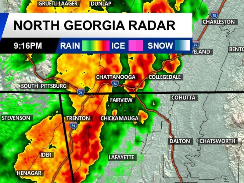
NORTHWEST GEORGIA — Heavy rainfall was moving through extreme northwest Georgia at 9:16 PM Saturday, April 18, 2026, with North Georgia radar showing an intense band of precipitation pushing through communities including Chattanooga, Chickamauga, Trenton, Fairview, and Henagar. The rainfall was described as a significant and welcome event for the region, with forecasters encouraging residents who were seeing the heavy rain Saturday evening to enjoy the much-needed precipitation.
Radar imagery showed deep orange and red reflectivity returns concentrated along a north-south oriented rainfall band stretching from the Chattanooga area southward through Chickamauga, Trenton, Ider, and Henagar, indicating heavy and potentially flooding rainfall rates beneath the most intense portions of the system.
Intense Rainfall Band Stretching Through the Region
The heaviest rainfall cores at the time of the 9:16 PM radar snapshot were concentrated along a corridor running from South Pittsburg and Chattanooga in Tennessee southward through Chickamauga and Trenton into the Ider and Henagar area of Alabama. The orange and red radar returns visible across this zone indicated rainfall rates well above light shower activity, with brief periods of very heavy downpours likely beneath the most intense cells within the band.
Communities along and near this rainfall corridor including Fairview, Scottsboro, Stevenson, and Summerville were also experiencing active rainfall as the broader precipitation shield pushed through the extreme northwest corner of Georgia and surrounding areas.
Welcome Rainfall for Drought Stressed Region
The heavy rainfall moving through northwest Georgia Saturday night represents a genuinely welcome development for a region that has been experiencing drier than normal conditions across recent weeks. The intensity of the rainfall band visible on radar suggests meaningful precipitation totals are possible for communities directly under the heaviest cores, providing some relief to stressed vegetation, water supplies, and fire-prone landscapes across the region.
Forecasters encouraged residents seeing this level of rainfall to appreciate the event, noting that opportunities for significant rainfall accumulation have been limited across northwest Georgia in recent weeks.
Flooding Possible Under Heaviest Cores
With orange and red radar returns indicating intense rainfall rates, brief periods of localized flooding cannot be ruled out under the heaviest portions of Saturday night’s rainfall band. Residents in low-lying areas near streams and creeks across Chickamauga, Trenton, and surrounding communities should monitor water levels closely through the evening hours.
Did you receive heavy rainfall Saturday night across northwest Georgia? Share your totals and stay connected at SaludaStandard-Sentinel.com.