Major Severe Weather and Tornado Outbreak Potential Builds Across Great Plains to Great Lakes for Late May as Euro Ensemble Model Signals 2004-Level Tornado Season Blossoming Into June
GREAT PLAINS, USA — Meteorologists are closely watching the final ten days of May for a significant and potentially historic uptick in severe weather and tornado activity stretching from the Great Plains through the Great Lakes region, as peak tornado season finally arrives and ensemble modeling data begins signaling the possible development of a highly active pattern reminiscent of the prolific 2004 tornado season.
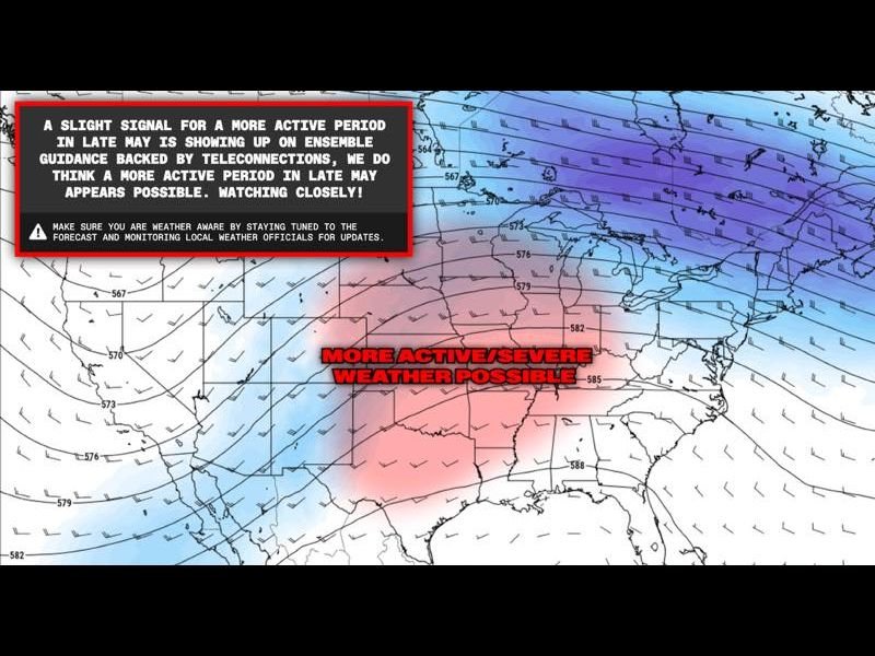
Euro Ensemble Model Flags Active Late May Pattern
The European Ensemble model, one of the most respected long-range forecasting tools available to meteorologists, is showing a slight but notable signal for a more active severe weather period developing during late May. The signal is backed by teleconnection data, adding additional confidence to the possibility that atmospheric conditions will become increasingly favorable for widespread severe weather development across the central United States as the month progresses toward its conclusion.
While forecasters are careful to note that ensemble signals at this range carry inherent uncertainty, the consistency of the data across multiple model runs warrants close monitoring and public awareness in the days ahead.
Textbook Trough-Ridge Pattern Set to Ignite Severe Weather
The atmospheric setup driving this potential outbreak period is described as a textbook trough-ridge pattern across the United States, a configuration widely recognized among meteorologists as one of the most reliable precursors to explosive severe weather and tornado outbreaks across the Great Plains. This type of pattern creates the necessary atmospheric ingredients including wind shear, moisture transport, and instability that collectively provide the fuel for significant and long-track tornado development.
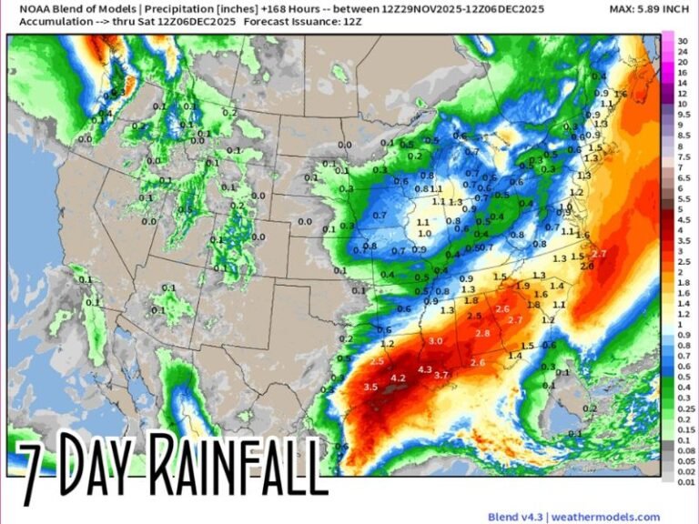
The Euro Ensemble 500mb wind analysis model run from May 7, 2026 clearly depicts this developing trough-ridge configuration, with the most active severe weather zone highlighted across the central and southern plains extending toward the Great Lakes corridor.
Comparisons to the Historic 2004 Tornado Season
Perhaps the most striking aspect of this forecast discussion is the reference to a potential 2004-style blossoming of the Great Plains tornado season during late May into June. The 2004 tornado season was marked by a dramatic and sustained period of intense tornado activity across the central United States, producing numerous significant and violent tornadoes across multiple states over an extended timeframe.
If current atmospheric signals verify, the late May through June period could deliver a similarly explosive outbreak pattern, elevating the threat level considerably for communities across the Great Plains, the Mississippi Valley, and into the Great Lakes region simultaneously.
Residents Urged to Prepare Now Ahead of Active Period
With the potential for a significantly active severe weather pattern developing within days, residents across the Great Plains and Great Lakes regions are strongly encouraged to review their severe weather safety plans, confirm the functionality of weather alert systems, and stay closely tuned to local forecast updates as the late May period approaches.
For continuing coverage of severe weather events and critical storm analysis across the United States, visit SaludaStandard-Sentinel.com.