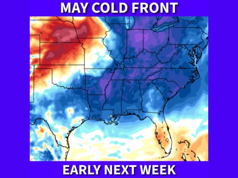
Another May Cold Front to Sweep Across the South Early Next Week Dropping Gulf Coast Temperatures to the 50s and Interior Southeast Into the 40s by Tuesday Morning
SOUTHEASTERN UNITED STATES — Another cold front is set to sweep across the southern United States early next week, delivering a striking late-season temperature drop that will push Gulf Coast morning lows into the 50s and drive interior portions of the Southeast all the way down into the 40s by Tuesday morning, a notable cold shot for a region rapidly approaching summer conditions.
Another Cold Front Defies the Calendar
Despite summer rapidly approaching, the southern United States finds itself in the path of yet another cold frontal passage, continuing a pattern of late-season cold intrusions that have repeatedly interrupted the seasonal warm-up across the region. Temperature forecast imagery shows a broad and deep pool of cold air represented in intense blue and purple tones blanketing virtually the entire eastern half of the country, stretching from the northern plains southward all the way to the Gulf Coast and Florida peninsula.
The persistence of these cold front passages well into May underscores an active and unsettled pattern that has refused to release its grip on the South despite the advancing calendar.
Tuesday Morning Will Be the Coldest Point
Forecasters identify next Tuesday morning as the peak of the cold shot, when temperatures will reach their lowest point across the affected region. Gulf Coast communities, which typically experience mild to warm conditions by this point in May, will see morning temperatures dropping into the 50s — readings more characteristic of early spring than late May.
Interior portions of the Southeast face an even more pronounced chill, with temperatures expected to fall into the 40s across inland areas during the Tuesday morning hours. Residents who have already transitioned into warm-weather routines may find the conditions noticeably jarring given the time of year.
Widespread Coverage Across the South and East
The temperature forecast map shows the cold air mass extending across an exceptionally wide geographic footprint, covering the majority of the eastern United States from the Great Lakes southward through the Deep South. States including Mississippi, Alabama, Georgia, Tennessee, the Carolinas, and communities along the Gulf Coast all fall within the zone of significantly below-normal temperatures expected early next week.
The breadth of the cold front’s coverage means that millions of residents across multiple states will experience this late-season temperature departure simultaneously as the system pushes through.
Temporary Relief Before Warmth Returns
While the cold front will deliver a sharp and noticeable temperature drop, the event is expected to be temporary in nature as the broader seasonal trend toward summer warmth remains firmly in place. Residents across the South and Southeast are advised to enjoy the brief cool-down while it lasts, as conditions are expected to moderate and return toward more seasonable warmth following the passage of the frontal system through the region next week.
For continuing coverage of severe weather events and critical storm analysis across the United States, visit SaludaStandard-Sentinel.com.