Large Mesoscale Convective System Centered Over Kansas Early Sunday With History of 70 MPH Wind Gusts as Storm Tracks East at 45 MPH
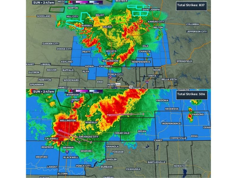
WICHITA, KS — A large complex of thunderstorms known as a Mesoscale Convective System was centered directly over Kansas early Sunday morning, with the southern edge of the storm carrying a history of producing severe wind gusts up to 60 to 70 mph as the system moved rapidly eastward at approximately 45 mph.
Storm Complex Spans a Wide Swath of Kansas
Radar imagery as of 2:48 AM Sunday showed the expansive storm system stretching from near Russell and Salina eastward through Wichita and toward Kansas City, with intense rainfall cores indicated by red and orange returns concentrated along the southern flank of the complex. The system’s broad coverage extended from the Hill City area in the northwest down through Wellington and Caldwell along the Oklahoma state line.
The most intense portion of the storm was tracking along a corridor stretching from Wichita through Independence and toward the southeastern Kansas border, with this southern edge identified as the section most prone to producing damaging wind gusts.
Southern Edge Carries Significant Wind Threat
Although no active severe weather warnings were in effect at the time of the update, forecasters noted that the southern edge of this Mesoscale Convective System has a documented history of producing severe wind gusts ranging from 60 to 70 mph. This characteristic placed communities along the storm’s southern flank, including Wellington, Caldwell, and areas near the Oklahoma border, at elevated risk as the system continued moving through.
Fast Eastward Movement Limits Duration of Impacts
The storm complex was moving at approximately 45 mph to the east, a relatively fast forward speed that was expected to limit the duration of impacts in any single location as the system rode along the Kansas-Oklahoma state line through the early morning hours. This rapid movement meant communities in the storm’s path would likely see conditions improve relatively quickly after the core of the system passed.
Forecasters Continue Monitoring Storm’s Progress
Despite the storm’s history of producing damaging winds, forecasters characterized the overall situation as nothing to be worried about at this time, while indicating they would continue watching the system closely as it tracked across the state line through the morning hours.
For continuing coverage of severe weather events and storm tracking across the United States, visit SaludaStandard-Sentinel.com.