Tropical Moisture Surge Targeting Western Gulf Coast Next Week With Low Pressure Development Possible and Flash Flooding as Primary Concern for Houston Region
HOUSTON, TX — Meteorologists are raising early awareness about a significant surge of tropical moisture poised to fill the western half of the Gulf of Mexico following the weekend, with low pressure development possible in the vicinity as hurricane season officially begins Monday and forecasters identify flash flooding as the primary threat wherever this moisture makes landfall along the Gulf Coast.
Tropical Moisture Building Into the Gulf
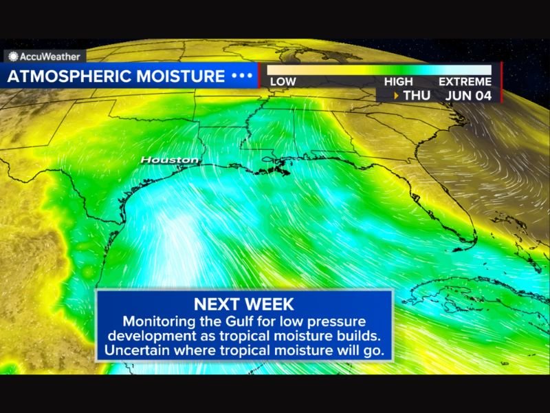
Atmospheric moisture imagery valid through June 4, 2026 shows an extreme moisture plume streaming northward from the tropics directly into the Gulf of Mexico, with the deepest and most concentrated moisture corridor oriented toward the western Gulf in a position that places the Texas and Louisiana coastlines within the potential path of tropical downpours during the coming week.
The sheer volume of atmospheric moisture depicted in the forecast imagery represents a significant rainfall potential regardless of whether any organized low pressure system develops, as the moisture itself carries the capacity to produce flooding rainfall when it interacts with land.
Low Pressure Development Possible but Not Certain
While wind shear across the Gulf is expected to remain fairly elevated through this period, limiting the potential for a well-organized tropical system to develop, forecasters acknowledge that a lopsided tropical depression or low-end tropical storm cannot be entirely ruled out given the favorable moisture environment that will be in place across the western Gulf after the weekend.
The combination of high wind shear and abundant tropical moisture creates a scenario where significant rainfall and flooding impacts remain possible even without a formally classified tropical system, since disorganized tropical moisture can still produce extreme precipitation totals when it pushes onshore.
Flash Flooding Is the Primary Concern
Regardless of how the atmospheric setup ultimately organizes, forecasters are united in identifying flash flooding as the dominant threat associated with this moisture surge wherever the tropical downpours make landfall along the Gulf Coast next week.
Communities across southeastern Texas including the Houston metropolitan area and portions of the Louisiana coast sit within the zone of greatest uncertainty and should begin monitoring updated forecasts closely as the weekend approaches and model guidance becomes more refined on the moisture’s eventual landfall location.
Uncertainty Remains High This Far Out
The exact track and landfall location of the moisture and any associated low pressure remains highly uncertain at this stage, with forecasters acknowledging they do not yet have a reliable handle on precisely where the heaviest tropical downpours will concentrate once the system approaches the coastline.
Residents across the western Gulf Coast are encouraged to stay closely connected to updated local forecasts through the weekend as confidence in the track and timing of this system improves in the days ahead. For continuing coverage of Gulf Coast tropical weather developments and flash flood threats across the United States, visit SaludaStandard-Sentinel.com.