Hot Dry and Breezy Saturday Brings 90s Across North Carolina Interior With Elevated Fire Danger Statewide as High Pressure Builds June 6
RALEIGH, NC — High pressure building across North Carolina on Saturday June 6, 2026 is delivering a hot, dry, and breezy weather day with high temperatures soaring into the low to mid 90s across most inland areas while the mountains and beaches hold in the upper 70s to mid 80s, with the combination of heat, low humidity, and gusty southwest winds of 5 to 20 miles per hour creating elevated fire danger conditions across the entire state throughout the day.
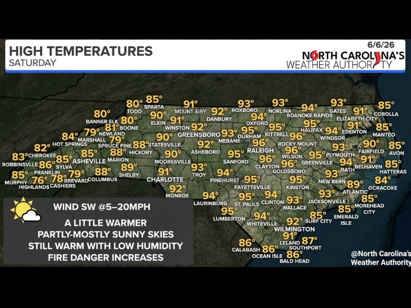
Temperature Map Shows Widespread 90s Across the Piedmont and Coastal Plain
North Carolina Weather Authority high temperature data for Saturday shows a broad swath of 90 degree plus readings blanketing the piedmont and coastal plain regions of the state, with some of the hottest readings concentrated across the central and eastern corridors.
Kittrell leads the state temperature rankings at 96 degrees with Rocky Mount, Wilson, Raleigh, Goldsboro, and Clayton all reaching 95 to 96 degrees across the central piedmont and upper coastal plain. Greensboro climbs to 92, Durham hits 95, Oxford reaches 94, and Fayetteville touches 95 degrees while communities across the Sandhills including Pinehurst and Southern Pines reach 94 and 95 degrees respectively during the afternoon peak heating hours.
Mountains and Coast Stay Cooler but Still Warm
Western North Carolina mountain communities are experiencing a considerably more comfortable but still warm Saturday, with Asheville reaching 85 degrees, Boone hitting 81, Banner Elk at 80, and Cashiers staying in the upper 70s as elevation provides meaningful but not dramatic temperature relief from the heat dominating the lower elevations.
Along the coast, communities including Wilmington, Surf City, and Morehead City sit in the mid 80s to low 90s with sea breeze interactions keeping temperatures several degrees below the inland values while simultaneously producing gusty coastal winds that contribute to the elevated fire danger present across the coastal plain zone.
Elevated Fire Danger the Key Concern Saturday
The most significant safety concern for Saturday across North Carolina is not the heat itself but the combination of warm temperatures, low humidity levels, and persistent southwest winds creating an elevated fire danger environment statewide that demands heightened awareness from residents and outdoor recreationists throughout the day.
Dry vegetation following recent below normal precipitation across portions of the state combined with gusty winds capable of rapidly spreading any ignition source makes Saturday a day where outdoor burning should be completely avoided and extreme caution exercised around any potential fire ignition sources across all regions of North Carolina.
For continuing coverage of North Carolina weather forecasts and fire danger alerts across the United States, visit SaludaStandard-Sentinel.com.