Heavy Rain and 571 Lightning Strikes Soak Citrus and Hernando Counties Florida Saturday Night With Non Severe but Intense Storm Activity Blanketing the Nature Coast Region
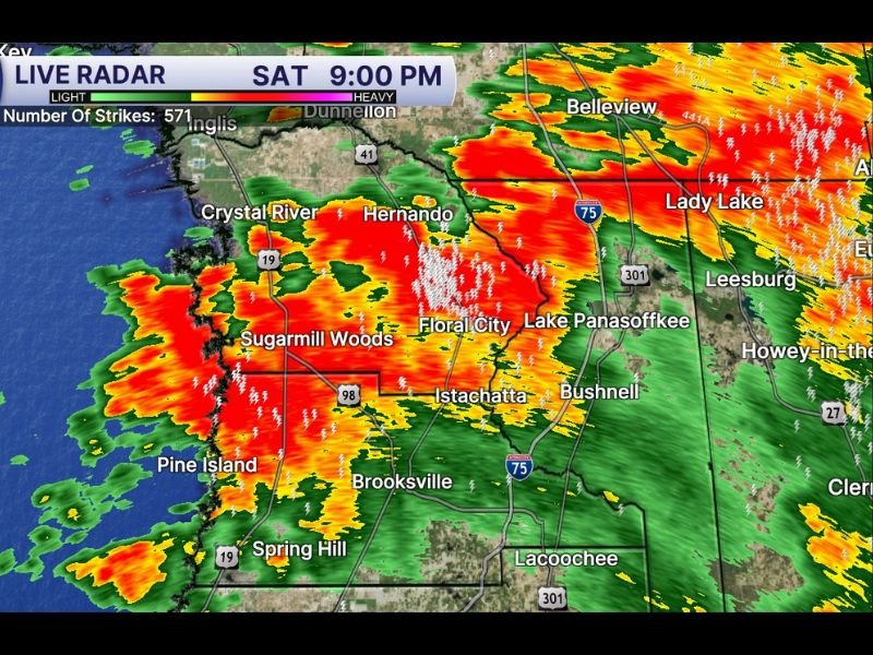
BROOKSVILLE, FL — Citrus and Hernando Counties along Florida’s Nature Coast are being absolutely drenched Saturday night as heavy rainfall and intense lightning activity blankets the region at 9:00 PM. Live radar from Tampa Bay Weather captured at the same time shows widespread red and orange reflectivity returns covering a broad zone from Crystal River and Hernando southward through Sugarmill Woods, Floral City, and Brooksville, with 571 total lightning strikes recorded across the region as the non-severe but highly active storm system saturates the area with heavy rainfall.
Citrus and Hernando Counties Soaked by Heavy Rain and Intense Lightning at 9 PM
Live radar at 9:00 PM shows an expansive area of heavy rainfall centered across Citrus and Hernando Counties, with deep red and orange returns concentrated from Crystal River southward through Sugarmill Woods, Floral City, and Brooksville toward Spring Hill and Pine Island along the Gulf Coast. The 571 lightning strikes recorded across the region at the time of observation reflect the highly electrified nature of the storm cells producing this heavy rainfall event despite the overall non-severe character of the system.
Communities including Hernando, Floral City, Istachatta, Bushnell, and Lake Panasoffkee all fall within the active heavy rainfall zone as the storm system continues saturating the Nature Coast region through the Saturday evening hours.
Non Severe System Produces Heavy Rain and Frequent Lightning Across the Nature Coast
Despite the dramatic radar presentation and high lightning strike count, forecasters have characterized Saturday night’s storm activity across Citrus and Hernando Counties as non-severe, with heavy rainfall and frequent lightning representing the primary hazards rather than the damaging winds or large hail associated with severe thunderstorm warnings. The 571 lightning strikes recorded across the region underscores the importance of remaining indoors and away from open areas during the storm’s passage even without a formal severe weather designation.
The heavy rainfall rates associated with the storm cells moving through Citrus and Hernando Counties carry the potential for localized street flooding and poor drainage issues across low lying communities throughout the Nature Coast region during the peak Saturday evening rainfall period.
Broader Storm Activity Extends From Dunnellon Through Lady Lake and Into Lake County
The broader radar picture shows active storm returns extending beyond the Citrus and Hernando County core, with heavy rainfall signatures visible from Dunnellon and Belleview northward and eastward through Lady Lake, Leesburg, and into Lake County communities. This expansive storm footprint across the Nature Coast and surrounding regions reflects the broad atmospheric moisture pool supporting widespread and persistent heavy rainfall development across this portion of Florida Saturday evening.
Residents across Citrus, Hernando, and surrounding counties are encouraged to remain indoors away from windows until the heavy rainfall and lightning activity fully clears the region through the overnight hours.
For continuing coverage of storm activity and heavy rainfall events across the United States, visit SaludaStandard-Sentinel.com.