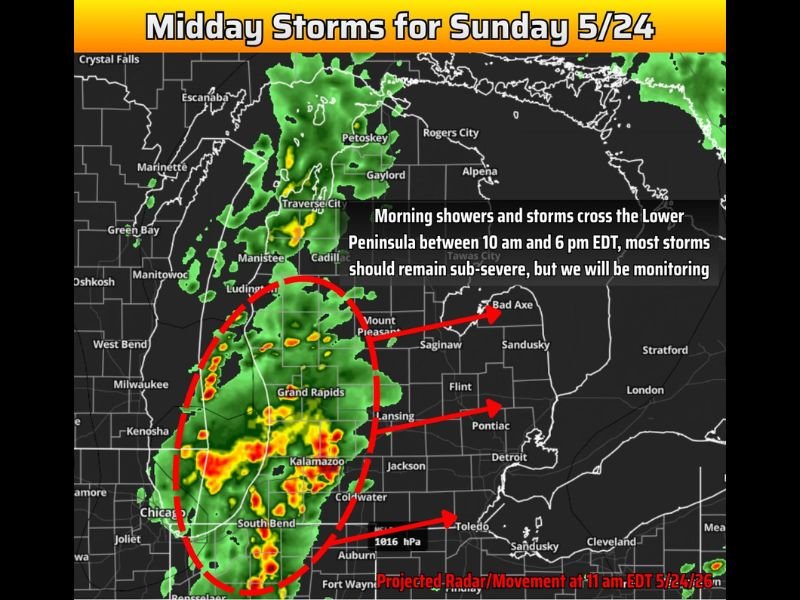
Midday Showers and Storms Cross Michigan Lower Peninsula Sunday May 24 Between 10 AM and 6 PM With Most Storms Expected Sub Severe and Borderline Wind and Hail Possible
GRAND RAPIDS, MI — Showers and storms are forecast to cross Michigan’s Lower Peninsula on Sunday, May 24, 2026, beginning as early as 9 to 10 AM Eastern Time on the west side of the state and finishing up by 6 PM EDT as the system progresses eastward through the afternoon. Most storms are expected to remain sub-severe throughout the day, though a low probability severe weather outlook will be issued as a precaution given the slim possibility of a surprise warning or two for borderline severe wind gusts near 60 mph or hail reaching 1 inch in diameter.
Showers and Storms Enter the West Side of Michigan Starting 9 to 10 AM Sunday
The storm system will make its first impact across the western side of Michigan’s Lower Peninsula between 9 and 10 AM Eastern Time, with projected radar imagery showing the storm complex positioned across the Grand Rapids and Kalamazoo corridor at approximately 11 AM EDT. The system will then track eastward throughout the afternoon, crossing through Lansing, Flint, and toward the Detroit and Pontiac areas as the day progresses toward the 6 PM EDT end of the primary storm window.
The best chance for storm activity rather than plain rain will be along and south of the Interstate 96 and Interstate 69 boundary, where atmospheric conditions are slightly more favorable for organized convective development during the afternoon hours.
Most Storms Expected Sub Severe but Borderline Warnings Cannot Be Ruled Out
While severe weather is not the primary expectation for Sunday’s Michigan storm system, forecasters are not completely dismissing the possibility of isolated borderline severe activity. If the system slows its forward speed, allowing additional storm fuel to build, a surprise warning or two for wind gusts approaching 60 miles per hour or hail reaching 1 inch in diameter cannot be entirely ruled out across the Lower Peninsula during the afternoon window.
A low probability severe weather outlook will be issued Sunday morning as an abundance of caution measure, reflecting the marginal but non-zero potential for the most isolated and strongest storm cells to briefly approach severe criteria during the afternoon hours.
Memorial Day Monday Expected to Offer Improvement After Sunday Storm System Clears
Sunday’s storm system will keep temperatures slightly cooler than typical for late May across Michigan throughout the day, offering a less than ideal end to the holiday weekend for residents hoping for summer conditions. However, forecasters indicate that Monday’s Memorial Day offers the prospect of improvement as the Sunday system clears the state and conditions trend toward a more pleasant pattern for the holiday.
Residents across the Michigan Lower Peninsula are encouraged to remain weather aware through Sunday afternoon and monitor updated outlooks issued Sunday morning before heading outdoors for any planned holiday weekend activities.
For continuing coverage of storm forecasts and severe weather tracking across the United States, visit SaludaStandard-Sentinel.com.