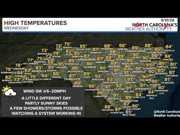
GFS and Euro Models Both Signal Potential Tropical System Development in the Gulf by June 5 Raising Early Awareness for the Gulf Coast as Long Range Uncertainty Remains High
NEW ORLEANS, LA — Both the GFS and European forecast models are depicting a potentially significant low pressure system developing in the Gulf of Mexico by June 5, 2026, drawing early attention from meteorologists monitoring the long range atmospheric setup ahead of the official start of summer.
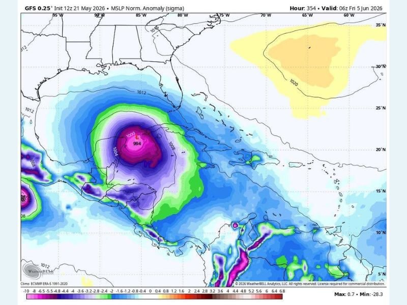
The GFS model shows a deep and well organized low pressure system with a central pressure near 994 millibars positioned over the Gulf, while the European model has independently arrived at a similar solution, a level of model agreement that elevates the signal from background noise to something worth monitoring despite the significant uncertainty that remains at this forecast range.
Both GFS and Euro Models Independently Depict Gulf Low Pressure Development by June 5
When two of the world’s premier global forecast models independently converge on a similar atmospheric solution at long range, the meteorological community takes notice even while acknowledging the considerable uncertainty inherent in 14 day forecasts. The GFS model, initialized at 12Z on May 21, 2026, and valid at 06Z on June 5, depicts a deep low pressure anomaly centered over the Gulf with surrounding pressure values indicating a potentially significant and organized system positioned south and west of the Gulf Coast states.
The independent agreement between the GFS and ECMWF models on Gulf low pressure development for early June raises the credibility of the signal without confirming the outcome, representing the meteorological equivalent of a watch rather than a warning at this forecast range.
Long Range Forecast Uncertainty Remains High Despite Dual Model Agreement
Despite the notable model agreement, forecasters are emphatic that the June 5 Gulf low pressure scenario remains firmly in the category of long range speculation rather than established forecast. Significant changes to the track, intensity, timing, and even existence of any Gulf system are entirely possible and expected as the forecast window narrows and updated model runs incorporate new atmospheric data over the coming days.
Gulf Coast residents from Texas through Florida are advised to be generally aware of the developing model signal without taking any specific preparatory action at this time, as the forecast will become considerably clearer and more reliable within the next seven to ten days.
Gulf Coast Residents Should Monitor Updates as the Forecast Window Narrows
The appropriate response to this long range model signal is awareness and monitoring rather than alarm, with residents across Gulf Coast states encouraged to stay tuned to updated forecast guidance as June 5 approaches and the atmospheric pattern becomes clearer. If the signal for Gulf low pressure development persists and strengthens in subsequent model runs through the coming week, the level of concern and preparedness guidance will be adjusted accordingly by forecasters tracking the evolving situation.
For continuing coverage of tropical weather development and long range forecast signals across the United States, visit SaludaStandard-Sentinel.com.