Tornado Warned Supercell Produces Confirmed Jameson Tornado Across Northern Missouri With Rapid Cycling Funnels and a Near Zero Meter Occlusion Captured Near Marysville
JAMESON, MO — A powerful tornadic supercell produced a confirmed tornado near Jameson in northern Missouri Wednesday, with the storm generating multiple tornado cycles including a confirmed bowl tornado near Marysville before the same updraft delivered a near zero-meter occlusion encounter during the Jameson tornado’s dramatic closing phase — one of the most visually intense supercell events documented across Missouri during the current severe weather outbreak.
How the Storm Unfolded
The day began with a dramatically shifted forecast, moving the primary storm target from northern Iowa southward into northern Missouri — a development that compressed available setup time significantly as storms initiated approximately two hours ahead of schedule. The rapid forecast evolution forced an urgent repositioning before the first tornado-warned storm began producing near Marysville.
The second storm in the sequence went tornado-warned and was intercepted as it cycled into its most intense phase. A confirmed bowl tornado — a shallow, wide tornado with a distinctive bowl-shaped condensation funnel — was documented from a distance near Marysville before the storm’s next cycle produced the Jameson tornado.
The Jameson Tornado
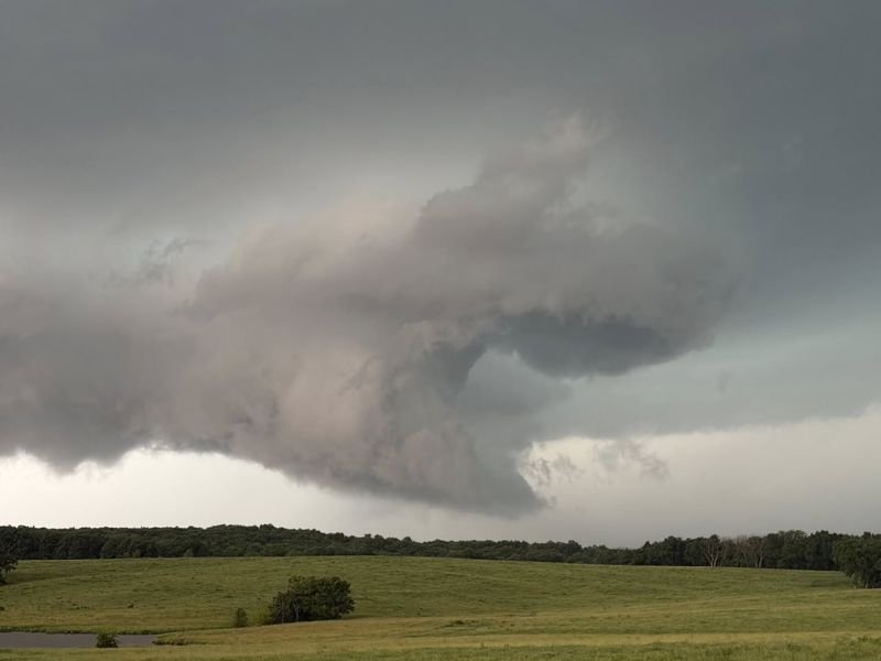
The Jameson tornado represented the storm’s most dangerous and dramatic cycle. The near zero-meter occlusion — referring to the rotation tightening to an extremely small, concentrated vortex at nearly ground level — was captured during the tornado’s final phase before it roped out. Photographs from the event show a well-defined funnel extending toward the tree line with a broad, lowered rotating base overhead, consistent with an actively cycling supercell at peak organization.
Following the Jameson tornado, the storm continued producing numerous funnel clouds through rapid cycling but did not generate another confirmed tornado before a new updraft developed near Kirksville.
What the Images Show
The six photographs captured during the chase document multiple stages of the storm’s lifecycle — from early funnel development against a summer green landscape to tight wall cloud rotation and the dramatic low-hanging occlusion structure during the Jameson tornado’s final moments. The storm’s structure visible in the images reflects a classic High Plains-style supercell operating in a rich moisture environment across the Missouri countryside.
The same atmospheric pattern responsible for Wednesday’s Missouri tornadoes remained active with additional significant storm potential expected across the region into Thursday.
For continuing coverage of tornado events and severe weather across Missouri and the United States, visit SaludaStandard-Sentinel.com.