Deep Tropical Moisture Targets Florida Over the Next Two Weeks With Up to 6 Inches of Rainfall Possible by June 5 as the Atmosphere Turns Significantly More Tropical
ORLANDO, FL — After a prolonged dry stretch, the season’s first real push of deep tropical moisture is showing up on forecast maps for Florida, with atmospheric modeling indicating that significant moisture pooling over the western Caribbean and Gulf of Mexico will be pulled northward toward the state over the next two weeks. The developing pattern signals a dramatic shift toward a more tropical atmosphere across Florida heading into late May and the first week of June, with widespread rainfall totals of up to 6 inches possible by June 5 across the wetter portions of the setup.
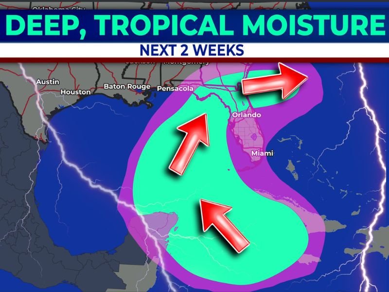
Deep Tropical Moisture to Pool Over Western Caribbean and Gulf Before Moving North
Forecast imagery shows deep tropical moisture currently positioned over the western Caribbean and Gulf of Mexico, with directional arrows indicating the moisture flow being pulled northward directly toward Florida over the coming two week period. The teal and purple shading on the moisture forecast map covers a broad area encompassing the entire Florida peninsula from Miami and Orlando northward through Pensacola, reflecting the wide geographic reach of the incoming tropical moisture surge toward the state.
This type of deep tropical moisture surge represents a fundamental shift in Florida’s atmospheric character from the dry pattern that has dominated recently toward the humid, storm prone conditions that define a typical Florida late spring and summer season.
Several Inches of Rain Possible by June 5 With Widespread 6 Inch Totals in the Wetter Setup
Some locations across Florida could pick up several inches of rainfall by June 5, with a widespread 6 inch total considered possible under the wetter end of the forecast setup. For perspective, 6 inches of rainfall would represent approximately six times what Florida typically averages during January, underscoring the significant magnitude of the moisture surge expected to impact the state over the coming two weeks as the tropical pattern becomes established.
Growing chances for heavy afternoon storms, increased humidity, and greater cloud coverage are all expected to accompany the deepening tropical moisture as the pattern evolves through late next week and into the first week of June.
Florida Atmosphere Set to Turn Significantly More Tropical Through Early June
The broader atmospheric pattern driving this moisture surge is considered credible by forecasters despite uncertainty around any specific storm system development near Cuba suggested by some models. The overall trajectory toward a significantly more tropical atmosphere across Florida through early June is viewed as the most reliable and meaningful aspect of the two week outlook for the state.
Residents across Florida from Miami and Orlando northward through Pensacola are encouraged to prepare for a return to active afternoon storm season conditions as deep tropical moisture arrives and transforms the state’s weather pattern through the coming weeks.
For continuing coverage of tropical moisture patterns and storm forecasts across the United States, visit SaludaStandard-Sentinel.com.