Stationary Front to Unleash Heavy Downpours and Flash Flood Risk Across Far Southwestern Pennsylvania Wednesday Morning With Peak Timing Between 6 AM and Noon
PITTSBURGH, PA — A stationary front positioned over the region is set to trigger heavy downpours and the possibility of isolated storms across far southwestern Pennsylvania on Wednesday morning, with forecasters identifying a low-end flash flood risk for low-lying and flood-prone communities during the active window.
Stationary Front Fueling the Threat
A stalled frontal boundary is the driving force behind this event, supplying persistent moisture into the southwestern corner of Pennsylvania and creating conditions favorable for repeated rounds of heavy rainfall over the same areas.
Unlike fast-moving storm systems that shift impacts quickly, a stationary front allows rain to train over the same communities for extended periods, dramatically increasing the potential for water accumulation and localized flooding in vulnerable locations.
Peak Timing and Affected Areas
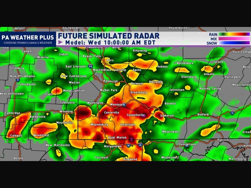
The window of greatest concern runs from 6 AM through 12 PM Wednesday morning, with simulated future radar imagery showing the heaviest activity concentrated across the southwestern Pennsylvania region.
Communities including Pittsburgh, Uniontown, Connellsville, Centerville, Monessen, Waynesburg, Morgantown vicinity, and Point Marion fall within the zone of highest radar-indicated rainfall, with surrounding areas including Greensburg, Johnstown, and Somerset also facing elevated exposure to the heavier downpour activity during this period.
Flash Flood Concern for Low-Lying Areas
The moisture-rich nature of these downpours raises a low-end flash flood risk, particularly for areas with poor drainage infrastructure, creek-side properties, and communities with a documented history of flood vulnerability.
Residents in these areas are strongly encouraged to remain weather-aware through the Wednesday morning hours, have reliable alert systems active, and avoid crossing flooded roadways should standing or moving water develop in their neighborhoods.
Isolated Storm Possibility Adds to Risk
Beyond the heavy rainfall, forecasters are monitoring the potential for one or two isolated storms to develop within the broader precipitation shield during the active timeframe.
Any storm that forms within this saturated environment could briefly enhance rainfall rates above the already elevated baseline, adding short bursts of intense precipitation on top of ongoing downpours before conditions gradually improve through the early afternoon hours. For continuing coverage of severe weather events and critical storm analysis across the United States, visit SaludaStandard-Sentinel.com.