Unusually Cold June Temperatures in the Low 50s Forecast Across Parts of the South and Gulf Coast Late Next Week Shocking Early Summer Expectations
ATLANTA, GA — Weather models are signaling a remarkable and historically atypical cold pattern set to grip large portions of the southern United States during the final days of next week, with temperatures potentially dropping into the low 50s Fahrenheit across areas that would normally be experiencing the full heat and humidity of early June.
What the Models Are Showing
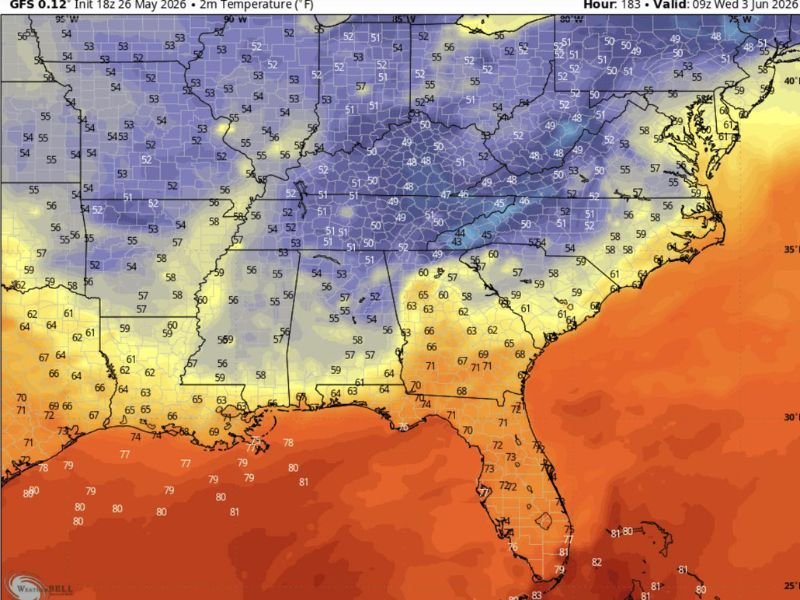
GFS model data valid for the morning of Wednesday, June 3, 2026, depicts a sweeping cold air intrusion pushing temperatures into the low to mid 50s across a broad swath of the South, including portions of the mid-South, Tennessee Valley, and areas extending toward the Gulf Coast region.
The temperature anomaly shown on the forecast map is striking, with deep blue and purple shading covering states that typically register significantly warmer readings during the first week of June, representing a departure from seasonal norms that forecasters describe as highly unusual for this time of year.
How Far South the Cold Reaches
Perhaps the most notable aspect of this forecast is how far southward the below-normal temperatures are projected to penetrate, with readings in the low to mid 50s indicated across portions of Mississippi, Alabama, and areas approaching the Gulf Coast corridor.
Even communities that typically see overnight lows well into the 60s and daytime highs climbing toward the upper 70s or 80s during early June could find themselves experiencing temperatures more reminiscent of late October than the beginning of meteorological summer.
Context and Seasonal Significance
A low 50s temperature reading in June across the Deep South is an exceptionally rare occurrence and stands in sharp contrast to the heat and high humidity that characterizes the region during this season.
Such an anomaly, if it verifies, would mark one of the more dramatic early June cold outbreaks on record for portions of the South, drawing considerable attention from meteorologists and climate observers monitoring the pattern evolution over the coming days.
Forecast Confidence and the Days Ahead
It is important to note that model forecasts at the 7 to 8 day range carry inherent uncertainty, and the exact magnitude and geographic footprint of this cold intrusion may shift as the event draws closer.
Residents across the South and Gulf Coast states are encouraged to monitor updated forecasts closely over the coming days as confidence in the pattern increases. For continuing coverage of weather patterns and climate developments across the United States, visit SaludaStandard-Sentinel.com.