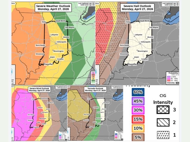
Enhanced Risk Severe Storms to Strike Illinois and Indiana Monday With EF3 Tornado Threat Near Terre Haute, Very Large Hail Across Central Illinois and 58 MPH Damaging Winds
ILLINOIS — The Storm Prediction Center has confirmed an Enhanced Risk of severe weather across most of Illinois and Indiana for Monday into Monday night, with three serious hazards all in play simultaneously. The biggest headline in this update is the tornado risk, with areas from Terre Haute northward and westward now placed in a CIG2 zone — meaning any tornadoes that form in that area could reach EF3 intensity or stronger.
This marks the first time since the SPC adopted its new tornado intensity forecasting method in early March that a CIG2 designation has been issued for this region.
Tornado Threat Is the Biggest Concern
The CIG2 hatched area covering Terre Haute and points north and west represents the most alarming element of Monday’s forecast. If tornadoes develop within that zone, atmospheric conditions are favorable enough that they could intensify to EF3 or greater, capable of destroying well-built homes and causing catastrophic damage across a wide path.
Areas further east across central Indiana carry a lower tornado probability, with the threat weakening as storms move into central Indiana and points east Monday night, dropping to a Slight Risk for those farther east.
Very Large Hail Stays West
The highest risk for very large hail is concentrated across central Illinois and points west. The severe hail outlook shows elevated probability across that corridor, with the hail threat diminishing as storms track eastward through Indiana later Monday night.
Residents in central and western Illinois should be prepared for hailstones capable of causing serious damage to vehicles and property during the afternoon and evening hours.
Damaging Winds Widespread
Wind is a concern across a large portion of the affected area, with damaging winds of 58 miles per hour or higher at an elevated risk for much of Illinois and Indiana. The severe wind outlook shows broad coverage across both states, making this a hazard that nearly everyone in the Enhanced Risk zone needs to account for regardless of their exact location.
Stay Weather Aware Monday and Into the Night
Forecasters are urging all residents across Illinois and Indiana to stay weather aware throughout Monday afternoon and into Monday night. Have multiple ways to receive warnings active before storms arrive. Additional updates are expected Sunday as the forecast continues to firm up. Share your storm reports at SaludaStandard-Sentinel.com.