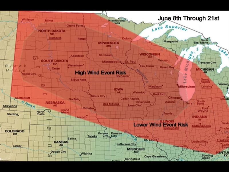
High Wind Event Risk Including Possible Derecho Targets North Dakota South Dakota Nebraska Minnesota and Iowa From June 8 Through June 21
OMAHA, NE — A prolonged and potentially significant wind event risk is forecast across a broad corridor of the northern and central plains from June 8 through June 21, with North Dakota, South Dakota, Nebraska, Minnesota, and Iowa falling within the high wind event risk zone as a broadly active northwest flow pattern supports repeated complexes of thunderstorms capable of producing damaging straight line winds and possibly derecho conditions during the two week period.
Pattern Supports Repeated Wind Producing Storm Complexes
The atmospheric setup driving the elevated wind event risk through mid June involves a broad northwest flow pattern combined with periodic troughing and episodes of deeply moist air mass conditions that create favorable environments for large and organized thunderstorm complexes to develop and sustain themselves across long tracks over the northern and central plains.
When these ingredients align during the June through August period, the result is frequently a mesoscale convective system or squall line capable of producing widespread damaging wind gusts across hundreds of miles of territory, with the most organized events occasionally reaching derecho classification when winds exceed severe thresholds continuously over a distance of at least 250 miles.
Derecho Possible but Not Certain
Forecasters note that while the pattern from June 8 through June 21 is favorable for wind event development, there is no certainty that a derecho will occur during this specific timeframe, as the precise timing and organization of individual storm complexes depends on details that cannot be reliably determined weeks in advance.
What the pattern does reliably signal is that the atmospheric environment will be repeatedly supportive of organized and potentially damaging wind producing thunderstorm complexes across the high risk zone, making wind damage a more probable threat than tornado activity during this particular period as severe weather characteristics shift toward the more wind-dominated pattern typical of deeper summer across the plains.
Geographic Risk Zones Across the Region
The risk map depicts two distinct zones of wind event concern across the affected region, with the high wind event risk concentrated across North Dakota, South Dakota, Nebraska, Minnesota, Iowa, and Wisconsin forming the primary threat corridor during the June 8 through June 21 window.
A lower but still meaningful wind event risk extends southeastward across Illinois, Missouri, Indiana, and portions of surrounding states, reflecting the broader geographic footprint that large organized thunderstorm complexes can cover as they track across the plains and into the upper midwest during this pattern.
For continuing coverage of wind event threats and severe weather pattern analysis across the United States, visit SaludaStandard-Sentinel.com.