Damaging Winds and Tornado Possible Across Gainesville, Cedar Key, Chiefland, and Ocala as Cold Front Storm Line Strikes Central and North Florida Saturday
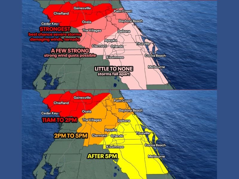
GAINESVILLE, FL — A line of storms driven by an approaching cold front was forecast to impact central and north Florida on Saturday, with the strongest and most dangerous storm activity concentrated across Gainesville, Cedar Key, Chiefland, and Ocala during the midday hours, where damaging winds and a briefly strong tornado were considered possible threats.
Storm arrival timing showed the Gainesville and Ocala corridor facing impacts between 11 AM and 2 PM, with the storm line pushing southeastward through The Villages, Apopka, and Orlando between 2 PM and 5 PM before reaching the Space Coast corridor after 5 PM.
Gainesville to Cedar Key Faces Strongest Severe Risk
The highest severe weather potential was concentrated across the Gainesville, Cedar Key, Chiefland, and Ocala region, where conditions were most favorable for damaging winds and an isolated tornado during the midday storm window. A briefly strong tornado remained possible between Gainesville and Cedar Key if any storms managed to remain isolated rather than merging into the broader line during the critical midday hours.
Storm intensity maps designated this western corridor as the strongest zone with the best chance for severe storms, damaging winds, and tornado development during the Saturday cold front passage.
Storms Weaken Significantly Approaching Orlando and Space Coast
As the storm line pushed eastward past Ocala and toward the Orlando metro area, wind energy aloft was expected to depart the region, causing storms to weaken and fall apart considerably. Orange, Osceola, and Brevard counties were forecast to see the storm line break up significantly, with some locations potentially receiving little to no rainfall at all as the system lost its organization approaching the Space Coast.
The storm intensity map clearly showed the transition from strongest conditions in the west to little to none across Melbourne, Cocoa Beach, and the Space Coast corridor.
Timing and Preparation Key for Affected Communities
With the most dangerous window running from 11 AM through 2 PM across the Gainesville and Ocala corridor, residents in those communities were urged to complete outdoor activities and secure property before late morning Saturday. Communities further southeast including Orlando, Kissimmee, Daytona Beach, and the Space Coast faced a much lower severe threat as the storm line was expected to diminish well before reaching those areas.
For continuing coverage of severe weather events and critical storm analysis across the United States, visit SaludaStandard-Sentinel.com.