Cool Temperatures and Low Humidity to Grip Gulf Coast, Alabama, Mississippi, Tennessee and Carolinas May 1 Through 3 Before Dangerous Heat Surges Back
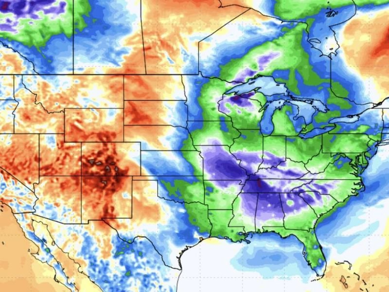
GULF COAST — A brief but welcome window of cool and comfortable weather is set to settle across the Gulf Coast from May 1 through May 3, bringing low humidity and pleasant overnight temperatures to a region that will soon be locked back into the grip of intense Gulf heat. Temperature anomaly maps show a broad zone of significantly below-normal temperatures covering the Gulf Coast, Southeast, Mississippi, Alabama, Tennessee, and the Carolinas during this short but refreshing break from seasonal warmth.
The cool pattern is being driven by a deep blue and purple anomaly zone pushing across the central and eastern United States, signaling a meaningful departure from what residents across the Gulf Coast have come to expect during this time of year.
What to Expect May 1 Through May 3
The three-day window from May 1 through May 3 will feature conditions that stand in sharp contrast to what typically grips the Gulf Coast heading into summer. Low humidity levels will make outdoor conditions feel genuinely comfortable, and overnight temperatures will drop enough to make for pleasant sleeping conditions across the region.
For residents who have already been dealing with warm and humid conditions building across the South, this brief cool stretch offers a rare opportunity to enjoy outdoor activities, open windows, and lower energy bills before the heat returns in force.
Gulf Heat Surges Back After May 3
The comfortable pattern will not last long. After May 3, the atmospheric setup shifts dramatically as Gulf heat builds back into the region with intensity. Temperatures are expected to surge back toward the mid to upper 90s, with overnight lows offering little relief as humidity returns and presses back across the Gulf Coast and surrounding states.
The contrast between the May 1 through 3 cool window and what follows makes the timing particularly stark. Residents should take full advantage of the pleasant conditions during those three days before the heat reasserts itself across the entire region.
Western US Seeing Opposite Pattern
While the Gulf Coast and eastern United States enjoy below-normal temperatures through early May, the western United States is experiencing a dramatically different pattern. Temperature anomaly maps show deep red and orange coverage across the West, indicating significantly above-normal temperatures baking states from the Southwest through the Rockies during the same period.
This sharp temperature contrast between east and west reflects the broader atmospheric pattern driving the cool air push into the Gulf Coast region and is consistent with the type of large-scale setup that can also fuel active severe weather development along the boundary zone between the two air masses.
Are you enjoying the cool break across the Gulf Coast this week? Share your experience and stay informed at SaludaStandard-Sentinel.com.