Baseball Size Hail and 60 MPH Winds Strike Sayre Oklahoma Under Destructive Warning as Severe Thunderstorm Moves Southeast Toward Elk City at 20 MPH
SAYRE, OK — A Destructive Severe Thunderstorm Warning has been issued for Sayre, Oklahoma as an extremely dangerous storm producing baseball size hail and 60 mile per hour wind gusts sits directly over the community and advances southeastward at 20 miles per hour, placing Sayre and all communities in its forward path under an immediate and life-threatening severe weather situation.
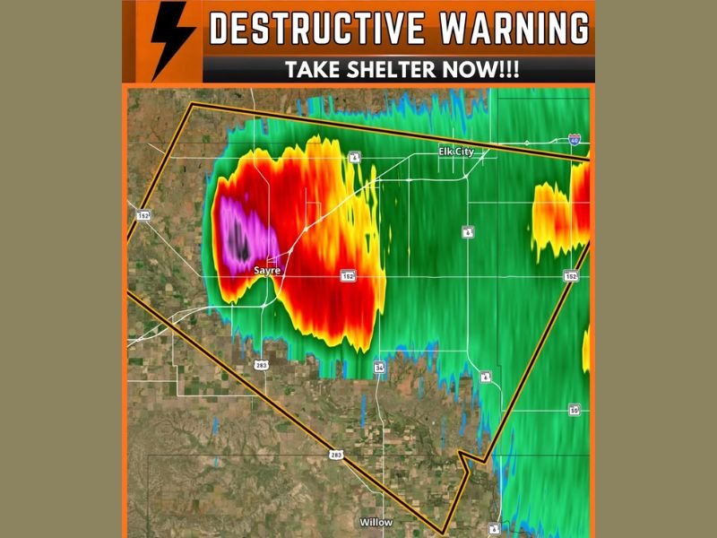
Destructive Warning Issued — The Highest Severe Thunderstorm Designation
The Destructive tag attached to this Severe Thunderstorm Warning represents the highest and most serious classification available within the severe thunderstorm warning category, reserved exclusively for storms producing or expected to produce catastrophic damage across impacted communities. The designation confirms that the storm over Sayre is not a routine severe event but rather one of the most dangerous thunderstorm situations that can be documented across Oklahoma’s severe weather season.
Residents within the warning polygon are instructed to take shelter immediately without delay in the lowest interior room of a sturdy structure.
Baseball Size Hail Confirmed With the Storm
Baseball size hail measuring approximately 2.75 inches in diameter is confirmed with the destructive storm over Sayre, representing one of the largest and most damaging hail sizes that a severe thunderstorm can produce. Hail of this magnitude falls with extraordinary force and velocity, capable of completely destroying vehicle exteriors, punching through roofing materials, shattering windows, and causing serious bodily injury to anyone caught outdoors during the storm’s passage.
Radar imagery shows the most intense returns, depicted in deep magenta and purple directly over Sayre, confirming the location of the most extreme precipitation and hail core within the warned storm.
Storm Tracking Southeast Toward Elk City at 20 MPH
Moving southeastward at 20 miles per hour, the destructive storm is advancing toward communities including Elk City and surrounding Beckham County areas within the warning polygon. At this forward speed, communities in the storm’s projected southeastern track have minimal time to prepare before the most dangerous hail and wind conditions arrive.
All residents across Sayre, Elk City, and the broader warning zone must treat this situation with maximum urgency and seek substantial shelter immediately.
For continuing coverage of severe weather events and critical storm analysis across the United States, visit SaludaStandard-Sentinel.com.