Strong Thunderstorm Packing Heavy Rain Intense Lightning and Possible Hail Strikes Benton and Carroll Counties in Northwest Arkansas Saturday Evening
BENTONVILLE, AR — The strongest thunderstorm of several that developed across northwest Arkansas Saturday is actively impacting Benton and Carroll counties as of 8:07 PM Saturday evening, bringing heavy rain, an enormous volume of lightning strikes, and the potential for hail and strong wind gusts to communities across the Bentonville, Rogers, Pea Ridge, Avoca, Garfield, and Bella Vista corridor as radar depicts an exceptionally intense and well-organized storm core over the region.
Radar Shows Extremely Intense Storm Core
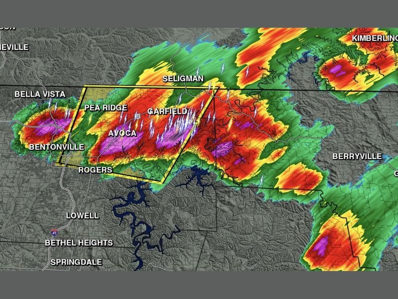
Arkansas Weather Network radar imagery captured at 8:07 PM Saturday shows one of the most visually striking storm presentations of the evening, with deep magenta and red reflectivity values blanketing a large portion of the Benton and Carroll county border area and extending across the warning polygon encompassing Pea Ridge, Avoca, Garfield, and the surrounding communities northeast of Bentonville and Rogers.
The density and frequency of lightning strikes visible across the radar presentation is particularly notable, with dozens of lightning indicators scattered throughout the storm core reflecting the extremely electrified nature of the cell as it pushes through the northwest Arkansas landscape during the Saturday evening hours.
Communities Directly in the Storm’s Path
The active warning polygon on radar encompasses a focused corridor running from the Bentonville and Bella Vista area northeastward through Pea Ridge, Avoca, and Garfield toward the Carroll County communities near Seligman, placing these northwest Arkansas communities under the most immediate and intense threat from the ongoing storm activity at the time of the radar capture.
Rogers and surrounding Benton County communities south of the primary storm core also fall within the broader heavy precipitation shield, with significant rainfall rates and frequent lightning activity extending across a wide area well beyond the most intense storm core boundaries visible on radar.
Hail and Strong Winds Possible
Beyond the heavy rainfall and prolific lightning, forecasters are monitoring the possibility of hail and strong wind gusts developing within the most intense portion of the storm cell tracking through Benton and Carroll counties during the Saturday evening period.
The storm’s radar presentation is consistent with a cell carrying sufficient organization and intensity to produce marginally severe weather impacts, making outdoor exposure extremely inadvisable for anyone within or near the affected communities until the storm moves through the area.
Warm and Humid Conditions Elsewhere
Across the portions of northwest Arkansas not currently impacted by Saturday evening’s storm activity, conditions remain warm and humid with the heat and moisture that fueled storm development throughout the day persisting across the region into the overnight hours.
Residents are encouraged to monitor updated radar closely through the evening as additional storm development remains possible across the warm and unstable air mass still in place across the broader Arkansas region. For continuing coverage of Arkansas severe weather and storm impacts across the United States, visit SaludaStandard-Sentinel.com.