Heavy Rain and Storms Push Through North Georgia and Atlanta Metro Friday Night With Slight to Medium Flood Risk Covering the Entire Greater Atlanta Region
ATLANTA, GA — Heavy rain and thunderstorms are pushing through north Georgia and the greater Atlanta metropolitan area Friday night, with FOX 5 Storm Team flood risk mapping depicting a broad zone of slight to medium flood risk covering the entire Atlanta metro corridor and surrounding north and central Georgia communities as the active storm system sweeps across the region.
Flood Risk Zone Covers Atlanta Metro Broadly
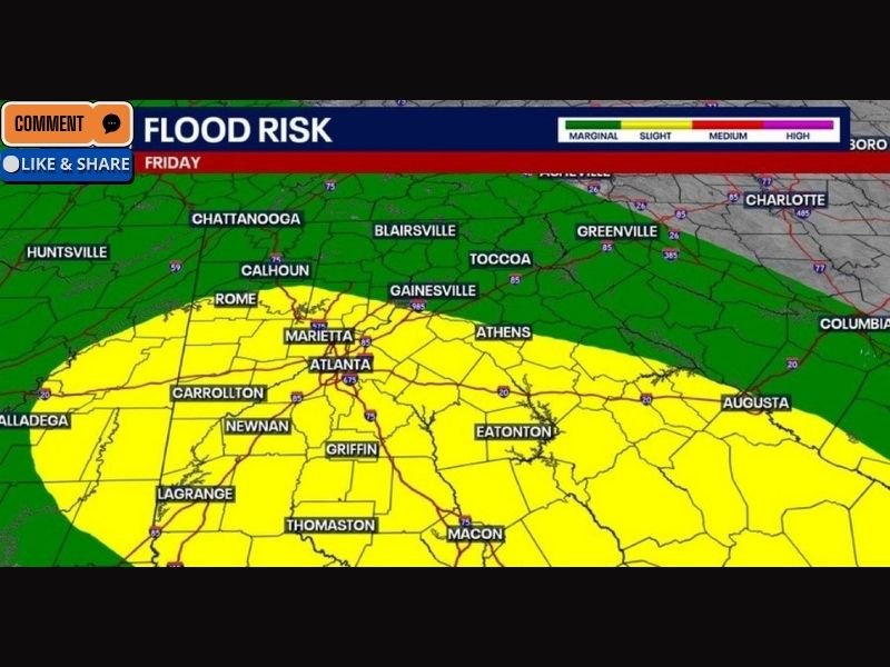
The Friday flood risk map shows a sweeping yellow shading zone indicating a slight flood risk extending across a remarkably large geographic area centered on metropolitan Atlanta and reaching outward in nearly every direction to encompass a substantial portion of the state.
Communities falling within the elevated flood risk zone include Atlanta, Marietta, Carrollton, Newnan, Griffin, LaGrange, Thomaston, Macon, Eatonton, Athens, Gainesville, Rome, and Calhoun, reflecting the broad and organized nature of the storm system pushing heavy rainfall across multiple Georgia counties simultaneously during the Friday night hours.
Medium Risk Zone Targets North Georgia Communities
A more concentrated medium flood risk zone shown in the deeper yellow shading on the forecast map is centered across the north Georgia foothill and mountain communities, with Gainesville, Toccoa, Blairsville, and the surrounding corridor falling within the area where rainfall accumulation and runoff potential is highest during Friday night’s storm event.
North Georgia’s terrain characteristics make it particularly susceptible to rapid water accumulation and creek and stream flooding during heavy rain events, as the mountainous and hilly landscape channels rainfall quickly into lower elevation valleys, hollows, and waterways that can rise with dangerous speed during periods of intense precipitation.
Storm Movement Through the Metro Area
Heavy rain and embedded storm cells are actively pushing through the north Georgia and Atlanta metropolitan area during the Friday evening hours, bringing the potential for locally intense downpours capable of producing standing water on roadways, overwhelmed storm drainage systems, and dangerous flash flooding in low-lying and flood-prone neighborhoods across the metro region.
Motorists across the Atlanta area are strongly urged to exercise extreme caution when encountering any standing water on roadways during the storm’s passage and to never attempt to drive through flooded road sections regardless of the apparent water depth.
Conditions Expected to Improve Overnight
The storm system is expected to continue tracking across the region through the evening hours before conditions gradually improve as the precipitation shield moves eastward and the flood risk diminishes across the western portions of the state overnight.
Residents across north Georgia, the Atlanta metro area, and central Georgia communities are encouraged to remain weather-aware throughout Friday night and monitor local alerts for any flash flood warnings issued for their specific county. For continuing coverage of flood risks and severe weather events across the United States, visit SaludaStandard-Sentinel.com.