Powerful Wind Gusts Up to 49 MPH Set to Roar Across Connecticut Saturday With Hartford Corridor and Northern Communities Facing the Strongest Impacts
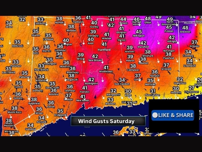
HARTFORD, CT — Connecticut is bracing for a significant and widespread wind event on Saturday as forecast wind gust maps show values ranging from the mid 30s to nearly 50 miles per hour across the entire state, with the strongest gusts concentrated across the Hartford metropolitan corridor and northern Connecticut communities where readings approaching 49 miles per hour are indicated during the peak of the wind event.
Northern Connecticut Faces Highest Gusts
The northern tier of Connecticut will experience the most intense wind activity on Saturday, with forecast gust values across communities including North Grosvenordale, Union, Stafford Hollow, Somers, and Longmeadow approaching the upper range of the forecast at 46 to 49 miles per hour.
These values represent a significant wind event for late May, a period when fully leafed trees dramatically increase the vulnerability of the landscape to wind-related damage including downed branches, toppled trees, and associated power outages across neighborhoods, roadways, and utility corridors throughout the northern Connecticut region.
Hartford Metro and Central Connecticut at Risk
The greater Hartford metropolitan area including New Britain, Middletown, Wallingford, Hamden, New Haven, Bristol, Windsor, and Avon falls within a zone forecast to see peak gusts ranging from 39 to 42 miles per hour, placing central Connecticut squarely within the range where tree and limb damage becomes a meaningful concern alongside scattered power disruptions.
Communities along and near the Interstate 91 corridor through the Hartford and New Haven counties represent the densely populated core of the wind impact zone, where a large number of residents and infrastructure systems face exposure to the Saturday wind event during its peak intensity period.
Western and Coastal Connecticut Less Impacted
Western Connecticut communities including Danbury, Waterbury, Brookfield, New Milford, Litchfield, and coastal areas including Stamford, Norwalk, Bridgeport, and Greenwich are forecast to see peak gusts in the 33 to 38 miles per hour range, still breezy and potentially disruptive but generally below the threshold where widespread tree damage and power outage risk becomes significant.
Coastal Sound communities across the southwestern corner of the state will see the lightest wind impacts of any portion of Connecticut during Saturday’s event, though conditions will still be noticeably and uncomfortably gusty throughout the day.
Securing Outdoor Items Is Essential
The broad geographic scope of Saturday’s wind event across all of Connecticut means that residents statewide should take precautions before the winds arrive, including securing or storing loose outdoor furniture, decorations, trash and recycling containers, and any lightweight structures or equipment that could become airborne or damaged under sustained gusting conditions throughout the day.
For continuing coverage of wind events and severe weather impacts across the United States, visit SaludaStandard-Sentinel.com.