Overnight Rain and Possible Thunder Moving Onshore Along Western Florida Peninsula From Tampa to Cape Coral as Moisture Slowly Pushes East Wednesday Night
TAMPA, FL — A moisture-laden storm system situated over the Gulf of Mexico is slowly tracking eastward Wednesday night, bringing rounds of rain and the possibility of isolated thunder to communities along the western side of the Florida Peninsula from Spring Hill and Tarpon Springs southward through Tampa, Saint Petersburg, Bradenton, Sarasota Springs, North Port, and into the Cape Coral corridor overnight and into Thursday morning.
Radar Shows Heavy Moisture Offshore and Moving East
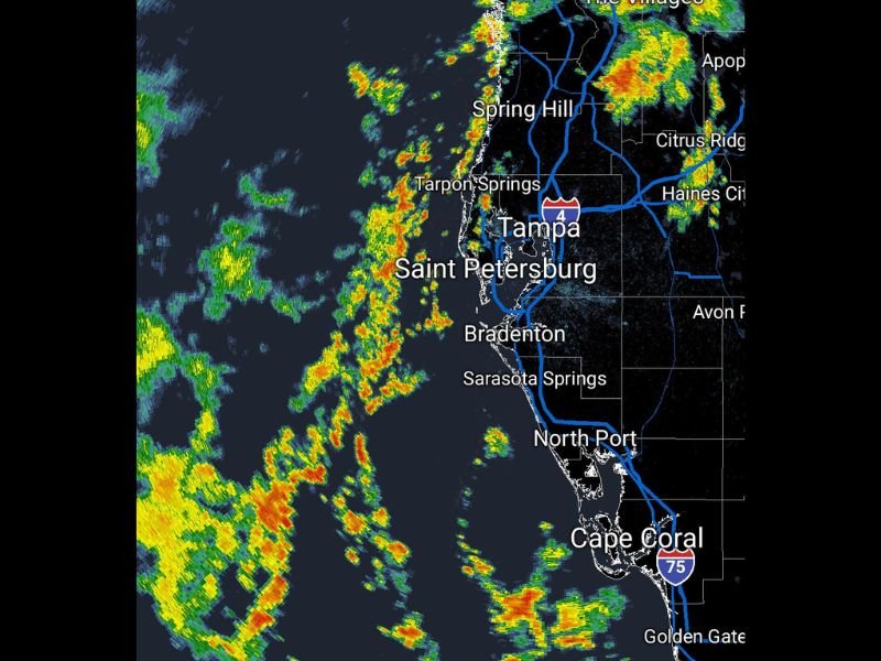
Wednesday night radar imagery reveals an expansive field of precipitation over the Gulf of Mexico displaying numerous pockets of intense orange and red reflectivity values embedded within the broader green precipitation shield, indicating a moisture-rich system carrying significant rainfall potential as it continues its slow eastward progression toward the Florida Gulf Coast.
The gradual and unhurried movement of this system means that coastal and near-coastal communities along the western peninsula will be exposed to the rainfall for an extended period through the overnight hours, rather than experiencing a quick-moving storm that clears rapidly and moves on.
Communities Along the Western Peninsula Most Exposed
The western side of the Florida Peninsula sits directly in the path of the advancing moisture, with communities from Spring Hill and Tarpon Springs in the north through the greater Tampa and Saint Petersburg metropolitan area and continuing southward through Bradenton, Sarasota Springs, North Port, and into the Cape Coral and Golden Gate areas facing the greatest overnight exposure.
Radar returns offshore show the heaviest precipitation cores positioned to make landfall across this corridor as the system inches eastward, suggesting that communities closest to the Gulf shoreline will receive rainfall first and potentially the heaviest accumulations during the overnight period.
Thunder Possible Within the Rain Shield
Beyond the rainfall itself, forecasters note the possibility of isolated thunder embedded within the advancing precipitation system as it moves onshore, a characteristic of moisture-dense Gulf systems that carry sufficient atmospheric instability to support occasional lightning and thunder even during overnight hours when convective activity typically diminishes.
Residents along the western Florida Peninsula are advised to be aware of this possibility if they are outdoors or near windows during the overnight period as the system moves through.
Thursday Morning Impact
The slow eastward movement of the system suggests that rainfall impacts will likely persist into the early Thursday morning hours across portions of the affected corridor before the precipitation gradually shifts further inland and conditions begin to improve along the immediate coastline. For continuing coverage of Florida weather and Gulf Coast storm developments across the United States, visit SaludaStandard-Sentinel.com.