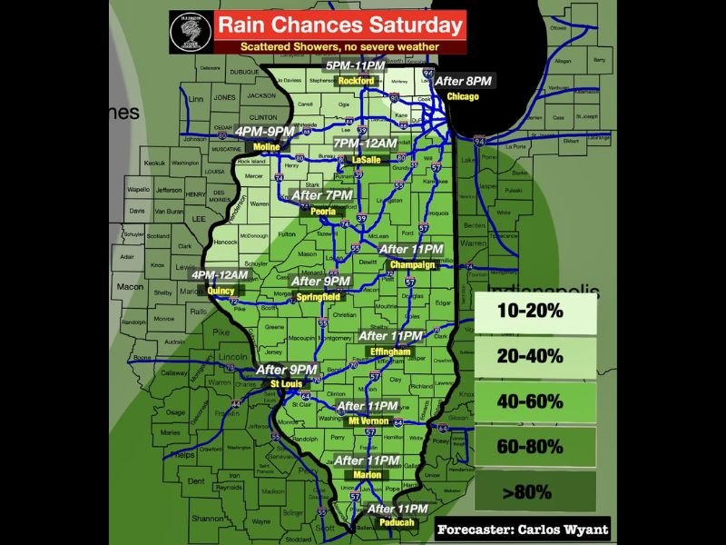
Scattered Showers Return to Illinois Saturday Evening Through Overnight With Staggered Timing From Moline and Quincy Through Chicago and No Severe Weather Expected Statewide
SPRINGFIELD, IL — Scattered showers will return to Illinois on Saturday, arriving at staggered times across different regions of the state from the afternoon hours through the overnight period. The rain chance timing map shows a progressive west to east movement of shower activity across Illinois through Saturday evening and overnight into Sunday morning, with no severe weather expected with this system and most locations seeing light rainfall totals of one tenth to one quarter of an inch with isolated higher amounts possible under stronger downpours.
Northwest Illinois and Moline Face the Earliest Shower Windows From 4 PM Onward
The earliest shower activity on Saturday will push into northwest Illinois and the Moline area beginning around 4:00 PM, with the Quincy corridor also tracking rain chances from 4:00 PM through midnight as showers move west to east across the western portions of the state. Rockford is expected to see shower activity between 5:00 PM and 11:00 PM, while the LaSalle corridor tracks its window from 7:00 PM through midnight as the shower line progresses eastward through the evening hours.
Northwest Illinois showers are expected to diminish after sunset as the initial wave moves through, with the more organized overnight moisture push arriving later across central and southern portions of the state.
Central Illinois Communities See Shower Activity From After 7 PM Through the Overnight
The Peoria area is forecast to see showers arriving after 7:00 PM, while Springfield tracks its window after 9:00 PM as the moisture push progresses southeastward through central Illinois. Chicago’s shower activity is expected after 8:00 PM, while Champaign, Effingham, Mt. Vernon, Marion, and Paducah all fall within an after 11:00 PM window as the overnight system delivers its moisture push to the central and southern portions of the state.
Rainfall totals across Illinois will vary, with most locations receiving one tenth to one quarter of an inch and isolated higher amounts exceeding half an inch possible under the heavier downpour cells within the shower complex.
Saturday Daytime Remains Largely Dry With No Severe Weather Expected Statewide
The good news for Saturday across Illinois is that the daytime hours will remain largely dry for most of the state, offering residents a pleasant window for outdoor activities before the evening shower activity arrives. The exception is northwest Illinois where showers push in after 3:00 PM, but the remainder of the state enjoys a dry Saturday before the staggered shower timing begins in the evening and overnight hours with no severe weather anticipated statewide.
For continuing coverage of rainfall forecasts and storm timing across the United States, visit SaludaStandard-Sentinel.com.